You are here: Home > Network List > AK - Alaska Regional Network Stations List
> Station BARN Barnard Glacier, AK, USA > Earthquake Result Viewer
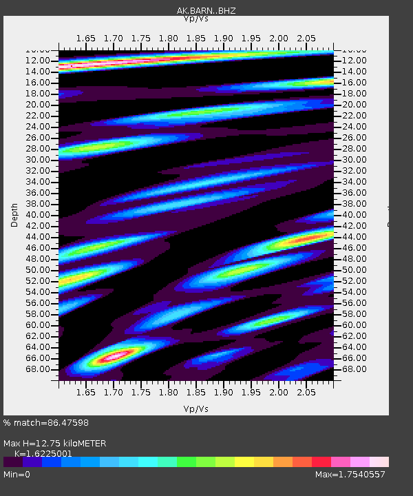
BARN Barnard Glacier, AK, USA - Earthquake Result Viewer
| Earthquake location: |
Mindanao, Philippines |
| Earthquake latitude/longitude: |
6.5/126.8 |
| Earthquake time(UTC): |
2021/08/11 (223) 17:46:14 GMT |
| Earthquake Depth: |
50 km |
| Earthquake Magnitude: |
7.2 Mi |
| Earthquake Catalog/Contributor: |
NEIC PDE/pt |
|
| Network: |
AK Alaska Regional Network |
| Station: |
BARN Barnard Glacier, AK, USA |
| Lat/Lon: |
61.06 N/141.66 W |
| Elevation: |
1689 m |
|
| Distance: |
85.1 deg |
| Az: |
29.207 deg |
| Baz: |
274.52 deg |
| Ray Param: |
0.04489251 |
| Estimated Moho Depth: |
12.75 km |
| Estimated Crust Vp/Vs: |
1.62 |
| Assumed Crust Vp: |
6.566 km/s |
| Estimated Crust Vs: |
4.047 km/s |
| Estimated Crust Poisson's Ratio: |
0.19 |
|
| Radial Match: |
86.47598 % |
| Radial Bump: |
400 |
| Transverse Match: |
58.97262 % |
| Transverse Bump: |
400 |
| SOD ConfigId: |
25131211 |
| Insert Time: |
2021-08-25 17:46:44.942 +0000 |
| GWidth: |
2.5 |
| Max Bumps: |
400 |
| Tol: |
0.001 |
|

Signal To Noise
| Channel | StoN | STA | LTA |
| AK:BARN: :BHZ:20210811T17:58:13.627991Z | 3.6394212 | 6.199204E-7 | 1.7033489E-7 |
| AK:BARN: :BHN:20210811T17:58:13.627991Z | 1.4643512 | 1.1216749E-6 | 7.6598764E-7 |
| AK:BARN: :BHE:20210811T17:58:13.627991Z | 1.3445324 | 9.304166E-7 | 6.920001E-7 |
| Arrivals |
| Ps | 1.2 SECOND |
| PpPs | 5.0 SECOND |
| PsPs/PpSs | 6.2 SECOND |


