You are here: Home > Network List > AK - Alaska Regional Network Stations List
> Station E21K Killik River, AK, USA > Earthquake Result Viewer
E21K Killik River, AK, USA - Earthquake Result Viewer
| Earthquake location: |
Mindanao, Philippines |
| Earthquake latitude/longitude: |
6.5/126.8 |
| Earthquake time(UTC): |
2021/08/11 (223) 17:46:14 GMT |
| Earthquake Depth: |
50 km |
| Earthquake Magnitude: |
7.2 Mi |
| Earthquake Catalog/Contributor: |
NEIC PDE/pt |
|
| Network: |
AK Alaska Regional Network |
| Station: |
E21K Killik River, AK, USA |
| Lat/Lon: |
68.44 N/153.97 W |
| Elevation: |
653 m |
|
| Distance: |
80.1 deg |
| Az: |
21.633 deg |
| Baz: |
262.391 deg |
| Ray Param: |
0.048451375 |
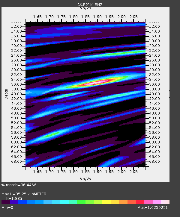
| Estimated Moho Depth: |
35.25 km |
| Estimated Crust Vp/Vs: |
1.88 |
| Assumed Crust Vp: |
6.221 km/s |
| Estimated Crust Vs: |
3.3 km/s |
| Estimated Crust Poisson's Ratio: |
0.30 |
|
| Radial Match: |
96.4466 % |
| Radial Bump: |
395 |
| Transverse Match: |
82.012115 % |
| Transverse Bump: |
400 |
| SOD ConfigId: |
25131211 |
| Insert Time: |
2021-08-25 17:47:27.433 +0000 |
| GWidth: |
2.5 |
| Max Bumps: |
400 |
| Tol: |
0.001 |
|

Signal To Noise
| Channel | StoN | STA | LTA |
| AK:E21K: :BHZ:20210811T17:57:47.320007Z | 4.283419 | 5.164964E-7 | 1.205804E-7 |
| AK:E21K: :BHN:20210811T17:57:47.320007Z | 1.1500703 | 6.847464E-8 | 5.953953E-8 |
| AK:E21K: :BHE:20210811T17:57:47.320007Z | 4.0841513 | 2.6159665E-7 | 6.4051655E-8 |
| Arrivals |
| Ps | 5.1 SECOND |
| PpPs | 16 SECOND |
| PsPs/PpSs | 21 SECOND |


