You are here: Home > Network List > AK - Alaska Regional Network Stations List
> Station M26K Nabesna, AK, USA > Earthquake Result Viewer
M26K Nabesna, AK, USA - Earthquake Result Viewer
| Earthquake location: |
Mindanao, Philippines |
| Earthquake latitude/longitude: |
6.5/126.8 |
| Earthquake time(UTC): |
2021/08/11 (223) 17:46:14 GMT |
| Earthquake Depth: |
50 km |
| Earthquake Magnitude: |
7.2 Mi |
| Earthquake Catalog/Contributor: |
NEIC PDE/pt |
|
| Network: |
AK Alaska Regional Network |
| Station: |
M26K Nabesna, AK, USA |
| Lat/Lon: |
62.40 N/143.00 W |
| Elevation: |
888 m |
|
| Distance: |
84.4 deg |
| Az: |
27.9 deg |
| Baz: |
273.228 deg |
| Ray Param: |
0.045415062 |
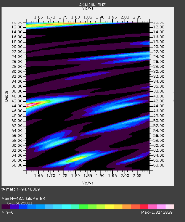
| Estimated Moho Depth: |
43.5 km |
| Estimated Crust Vp/Vs: |
1.60 |
| Assumed Crust Vp: |
6.566 km/s |
| Estimated Crust Vs: |
4.097 km/s |
| Estimated Crust Poisson's Ratio: |
0.18 |
|
| Radial Match: |
94.46889 % |
| Radial Bump: |
400 |
| Transverse Match: |
83.5478 % |
| Transverse Bump: |
400 |
| SOD ConfigId: |
25131211 |
| Insert Time: |
2021-08-25 17:49:01.488 +0000 |
| GWidth: |
2.5 |
| Max Bumps: |
400 |
| Tol: |
0.001 |
|

Signal To Noise
| Channel | StoN | STA | LTA |
| AK:M26K: :BHZ:20210811T17:58:10.000Z | 3.202646 | 4.4440645E-7 | 1.3876227E-7 |
| AK:M26K: :BHN:20210811T17:58:10.000Z | 0.5894359 | 7.099808E-8 | 1.2045089E-7 |
| AK:M26K: :BHE:20210811T17:58:10.000Z | 1.6506882 | 2.3343556E-7 | 1.4141712E-7 |
| Arrivals |
| Ps | 4.1 SECOND |
| PpPs | 17 SECOND |
| PsPs/PpSs | 21 SECOND |


