You are here: Home > Network List > AK - Alaska Regional Network Stations List
> Station M27K Edge Creek, AK, USA > Earthquake Result Viewer
M27K Edge Creek, AK, USA - Earthquake Result Viewer
| Earthquake location: |
Mindanao, Philippines |
| Earthquake latitude/longitude: |
6.5/126.8 |
| Earthquake time(UTC): |
2021/08/11 (223) 17:46:14 GMT |
| Earthquake Depth: |
50 km |
| Earthquake Magnitude: |
7.2 Mi |
| Earthquake Catalog/Contributor: |
NEIC PDE/pt |
|
| Network: |
AK Alaska Regional Network |
| Station: |
M27K Edge Creek, AK, USA |
| Lat/Lon: |
62.36 N/141.88 W |
| Elevation: |
1536 m |
|
| Distance: |
84.9 deg |
| Az: |
27.91 deg |
| Baz: |
274.218 deg |
| Ray Param: |
0.04503956 |
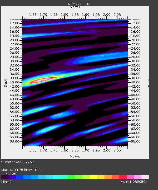
| Estimated Moho Depth: |
38.75 km |
| Estimated Crust Vp/Vs: |
1.69 |
| Assumed Crust Vp: |
6.566 km/s |
| Estimated Crust Vs: |
3.885 km/s |
| Estimated Crust Poisson's Ratio: |
0.23 |
|
| Radial Match: |
90.97757 % |
| Radial Bump: |
400 |
| Transverse Match: |
78.99283 % |
| Transverse Bump: |
400 |
| SOD ConfigId: |
25131211 |
| Insert Time: |
2021-08-25 17:49:03.993 +0000 |
| GWidth: |
2.5 |
| Max Bumps: |
400 |
| Tol: |
0.001 |
|

Signal To Noise
| Channel | StoN | STA | LTA |
| AK:M27K: :BHZ:20210811T17:58:12.619995Z | 1.7459207 | 3.9943777E-7 | 2.2878346E-7 |
| AK:M27K: :BHN:20210811T17:58:12.619995Z | 1.8276978 | 2.4741843E-7 | 1.3537162E-7 |
| AK:M27K: :BHE:20210811T17:58:12.619995Z | 1.5345001 | 3.2506193E-7 | 2.1183573E-7 |
| Arrivals |
| Ps | 4.2 SECOND |
| PpPs | 15 SECOND |
| PsPs/PpSs | 20 SECOND |


