You are here: Home > Network List > AK - Alaska Regional Network Stations List
> Station NIKH Nikolski High Hill > Earthquake Result Viewer
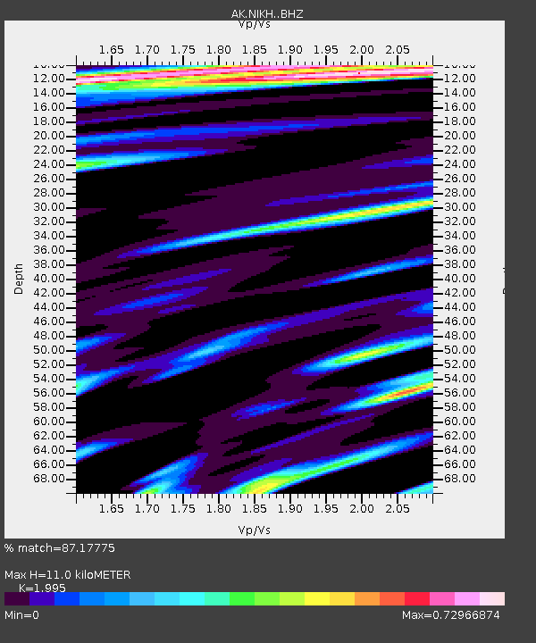
NIKH Nikolski High Hill - Earthquake Result Viewer
| Earthquake location: |
Mindanao, Philippines |
| Earthquake latitude/longitude: |
6.5/126.8 |
| Earthquake time(UTC): |
2021/08/11 (223) 17:46:14 GMT |
| Earthquake Depth: |
50 km |
| Earthquake Magnitude: |
7.2 Mi |
| Earthquake Catalog/Contributor: |
NEIC PDE/pt |
|
| Network: |
AK Alaska Regional Network |
| Station: |
NIKH Nikolski High Hill |
| Lat/Lon: |
52.97 N/168.85 W |
| Elevation: |
199 m |
|
| Distance: |
69.6 deg |
| Az: |
35.589 deg |
| Baz: |
252.984 deg |
| Ray Param: |
0.05546036 |
| Estimated Moho Depth: |
11.0 km |
| Estimated Crust Vp/Vs: |
2.00 |
| Assumed Crust Vp: |
5.88 km/s |
| Estimated Crust Vs: |
2.948 km/s |
| Estimated Crust Poisson's Ratio: |
0.33 |
|
| Radial Match: |
87.17775 % |
| Radial Bump: |
400 |
| Transverse Match: |
74.41643 % |
| Transverse Bump: |
400 |
| SOD ConfigId: |
25131211 |
| Insert Time: |
2021-08-25 17:49:16.820 +0000 |
| GWidth: |
2.5 |
| Max Bumps: |
400 |
| Tol: |
0.001 |
|

Signal To Noise
| Channel | StoN | STA | LTA |
| AK:NIKH: :BHZ:20210811T17:56:46.867981Z | 3.101047 | 9.097765E-7 | 2.9337718E-7 |
| AK:NIKH: :BHN:20210811T17:56:46.867981Z | 1.8302636 | 7.320691E-7 | 3.9998017E-7 |
| AK:NIKH: :BHE:20210811T17:56:46.867981Z | 1.7032344 | 6.2969104E-7 | 3.697031E-7 |
| Arrivals |
| Ps | 1.9 SECOND |
| PpPs | 5.5 SECOND |
| PsPs/PpSs | 7.4 SECOND |


