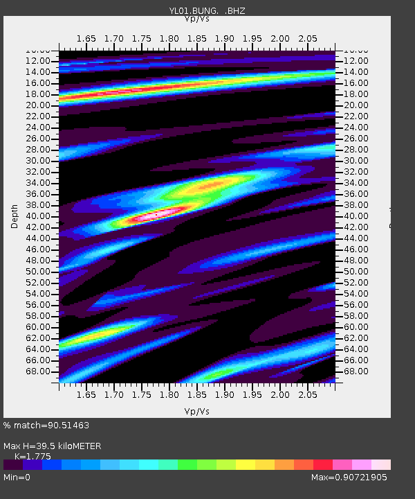
BUNG YL.BUNG - Earthquake Result Viewer
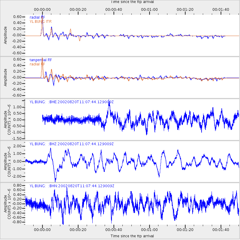
Earthquake location: Southeast Of Honshu, Japan
Earthquake latitude/longitude: 31.0/142.0
Earthquake time(UTC): 2002/08/20 (232) 10:59:32 GMT
Earthquake Depth: 9.0 km
Earthquake Magnitude: 5.4 MB, 6.2 MS, 6.3 MW, 6.1 MW
Earthquake Catalog/Contributor: WHDF/NEIC
Network: YL Himalayan Nepal Tibet Experiment
Station: BUNG YL.BUNG
Lat/Lon: 27.88 N/85.89 E
Elevation: 1191 m
Distance: 48.5 deg
Az: 281.268 deg
Baz: 72.071 deg
Ray Param: 0.06932165
Estimated Moho Depth: 39.5 km
Estimated Crust Vp/Vs: 1.77
Assumed Crust Vp: 6.142 km/s
Estimated Crust Vs: 3.46 km/s
Estimated Crust Poisson's Ratio: 0.27
Radial Match: 90.51463 %
Radial Bump: 400
Transverse Match: 78.525345 %
Transverse Bump: 400
SOD ConfigId: 16844
Insert Time: 2010-02-26 15:52:31.052 +0000
GWidth: 2.5
Max Bumps: 400
Tol: 0.001

Signal To Noise

ChannelStoNSTALTA
YL:BUNG: :BHZ:20020820T11:07:44.129009Z6.0635786.918321E-71.14096345E-7
YL:BUNG: :BHN:20020820T11:07:44.129009Z2.27438572.3604998E-71.0378626E-7
YL:BUNG: :BHE:20020820T11:07:44.129009Z1.97279523.1031843E-71.5729884E-7
Arrivals
Ps5.3 SECOND
PpPs17 SECOND
PsPs/PpSs22 SECOND