You are here: Home > Network List > AK - Alaska Regional Network Stations List
> Station TGL Tana Glacier > Earthquake Result Viewer
TGL Tana Glacier - Earthquake Result Viewer
| Earthquake location: |
Mindanao, Philippines |
| Earthquake latitude/longitude: |
6.5/126.8 |
| Earthquake time(UTC): |
2021/08/11 (223) 17:46:14 GMT |
| Earthquake Depth: |
50 km |
| Earthquake Magnitude: |
7.2 Mi |
| Earthquake Catalog/Contributor: |
NEIC PDE/pt |
|
| Network: |
AK Alaska Regional Network |
| Station: |
TGL Tana Glacier |
| Lat/Lon: |
60.75 N/142.83 W |
| Elevation: |
1260 m |
|
| Distance: |
84.6 deg |
| Az: |
29.553 deg |
| Baz: |
273.534 deg |
| Ray Param: |
0.045288276 |
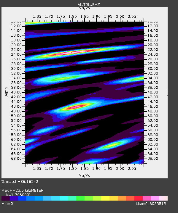
| Estimated Moho Depth: |
23.0 km |
| Estimated Crust Vp/Vs: |
1.80 |
| Assumed Crust Vp: |
6.566 km/s |
| Estimated Crust Vs: |
3.658 km/s |
| Estimated Crust Poisson's Ratio: |
0.27 |
|
| Radial Match: |
86.16242 % |
| Radial Bump: |
400 |
| Transverse Match: |
83.14601 % |
| Transverse Bump: |
400 |
| SOD ConfigId: |
25131211 |
| Insert Time: |
2021-08-25 17:50:09.220 +0000 |
| GWidth: |
2.5 |
| Max Bumps: |
400 |
| Tol: |
0.001 |
|

Signal To Noise
| Channel | StoN | STA | LTA |
| AK:TGL: :BHZ:20210811T17:58:10.888Z | 2.8116314 | 5.0808666E-7 | 1.8070884E-7 |
| AK:TGL: :BHN:20210811T17:58:10.888Z | 1.1746877 | 6.86089E-7 | 5.8406073E-7 |
| AK:TGL: :BHE:20210811T17:58:10.888Z | 1.2688675 | 7.5738546E-7 | 5.968988E-7 |
| Arrivals |
| Ps | 2.9 SECOND |
| PpPs | 9.5 SECOND |
| PsPs/PpSs | 12 SECOND |


