You are here: Home > Network List > AK - Alaska Regional Network Stations List
> Station TRF Thorofare Mountian, AK, USA > Earthquake Result Viewer
TRF Thorofare Mountian, AK, USA - Earthquake Result Viewer
| Earthquake location: |
Mindanao, Philippines |
| Earthquake latitude/longitude: |
6.5/126.8 |
| Earthquake time(UTC): |
2021/08/11 (223) 17:46:14 GMT |
| Earthquake Depth: |
50 km |
| Earthquake Magnitude: |
7.2 Mi |
| Earthquake Catalog/Contributor: |
NEIC PDE/pt |
|
| Network: |
AK Alaska Regional Network |
| Station: |
TRF Thorofare Mountian, AK, USA |
| Lat/Lon: |
63.45 N/150.29 W |
| Elevation: |
1710 m |
|
| Distance: |
81.1 deg |
| Az: |
26.836 deg |
| Baz: |
266.607 deg |
| Ray Param: |
0.047751363 |
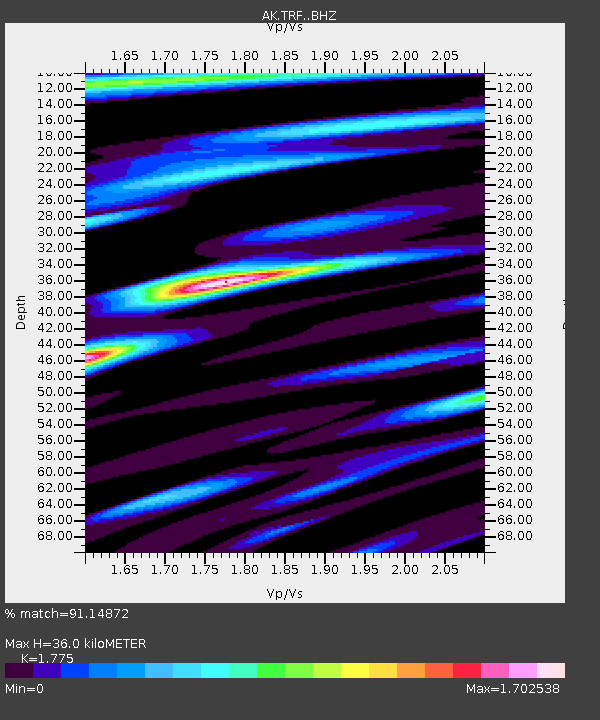
| Estimated Moho Depth: |
36.0 km |
| Estimated Crust Vp/Vs: |
1.77 |
| Assumed Crust Vp: |
6.438 km/s |
| Estimated Crust Vs: |
3.627 km/s |
| Estimated Crust Poisson's Ratio: |
0.27 |
|
| Radial Match: |
91.14872 % |
| Radial Bump: |
400 |
| Transverse Match: |
81.101746 % |
| Transverse Bump: |
400 |
| SOD ConfigId: |
25131211 |
| Insert Time: |
2021-08-25 17:50:12.013 +0000 |
| GWidth: |
2.5 |
| Max Bumps: |
400 |
| Tol: |
0.001 |
|

Signal To Noise
| Channel | StoN | STA | LTA |
| AK:TRF: :BHZ:20210811T17:57:52.768005Z | 5.923243 | 5.730934E-7 | 9.675332E-8 |
| AK:TRF: :BHN:20210811T17:57:52.768005Z | 0.5615118 | 1.1952687E-7 | 2.1286615E-7 |
| AK:TRF: :BHE:20210811T17:57:52.768005Z | 1.0332137 | 1.5157461E-7 | 1.4670208E-7 |
| Arrivals |
| Ps | 4.5 SECOND |
| PpPs | 15 SECOND |
| PsPs/PpSs | 20 SECOND |


