You are here: Home > Network List > AV - Alaska Volcano Observatory Stations List
> Station MTBL Table Top, Makushin Volcano, Alaska > Earthquake Result Viewer
MTBL Table Top, Makushin Volcano, Alaska - Earthquake Result Viewer
| Earthquake location: |
Mindanao, Philippines |
| Earthquake latitude/longitude: |
6.5/126.8 |
| Earthquake time(UTC): |
2021/08/11 (223) 17:46:14 GMT |
| Earthquake Depth: |
50 km |
| Earthquake Magnitude: |
7.2 Mi |
| Earthquake Catalog/Contributor: |
NEIC PDE/pt |
|
| Network: |
AV Alaska Volcano Observatory |
| Station: |
MTBL Table Top, Makushin Volcano, Alaska |
| Lat/Lon: |
53.97 N/166.68 W |
| Elevation: |
810 m |
|
| Distance: |
71.1 deg |
| Az: |
34.959 deg |
| Baz: |
254.513 deg |
| Ray Param: |
0.05445743 |
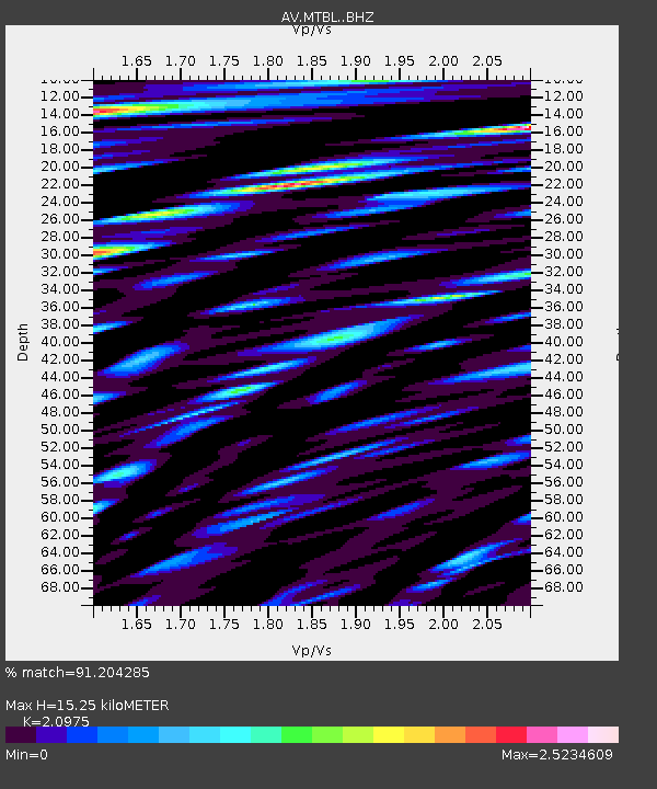
| Estimated Moho Depth: |
15.25 km |
| Estimated Crust Vp/Vs: |
2.10 |
| Assumed Crust Vp: |
3.943 km/s |
| Estimated Crust Vs: |
1.88 km/s |
| Estimated Crust Poisson's Ratio: |
0.35 |
|
| Radial Match: |
91.204285 % |
| Radial Bump: |
400 |
| Transverse Match: |
91.27415 % |
| Transverse Bump: |
400 |
| SOD ConfigId: |
25131211 |
| Insert Time: |
2021-08-25 17:52:05.689 +0000 |
| GWidth: |
2.5 |
| Max Bumps: |
400 |
| Tol: |
0.001 |
|

Signal To Noise
| Channel | StoN | STA | LTA |
| AV:MTBL: :BHZ:20210811T17:56:56.159973Z | 3.2219899 | 7.672369E-7 | 2.3812517E-7 |
| AV:MTBL: :BHN:20210811T17:56:56.159973Z | 1.408391 | 7.989517E-7 | 5.672798E-7 |
| AV:MTBL: :BHE:20210811T17:56:56.159973Z | 1.3169262 | 7.588229E-7 | 5.762076E-7 |
| Arrivals |
| Ps | 4.3 SECOND |
| PpPs | 12 SECOND |
| PsPs/PpSs | 16 SECOND |


