You are here: Home > Network List > IW - Intermountain West Stations List
> Station PLID Pearl Lake, Idaho, USA > Earthquake Result Viewer
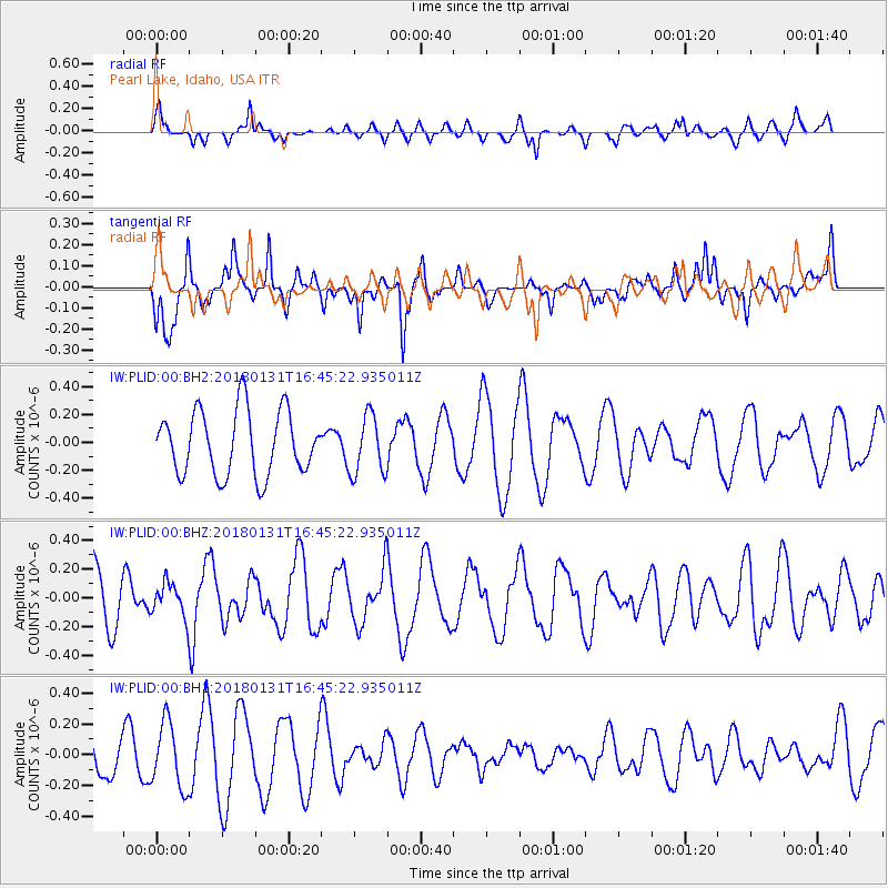
PLID Pearl Lake, Idaho, USA - Earthquake Result Viewer
*The percent match for this event was below the threshold and hence no stack was calculated.
| Earthquake location: |
South Of Panama |
| Earthquake latitude/longitude: |
7.2/-79.6 |
| Earthquake time(UTC): |
2018/01/31 (031) 16:37:06 GMT |
| Earthquake Depth: |
10 km |
| Earthquake Magnitude: |
5.7 Mww |
| Earthquake Catalog/Contributor: |
NEIC PDE/us |
|
| Network: |
IW Intermountain West |
| Station: |
PLID Pearl Lake, Idaho, USA |
| Lat/Lon: |
45.09 N/116.00 W |
| Elevation: |
2164 m |
|
| Distance: |
49.1 deg |
| Az: |
326.261 deg |
| Baz: |
128.933 deg |
| Ray Param: |
$rayparam |
*The percent match for this event was below the threshold and hence was not used in the summary stack. |
|
| Radial Match: |
57.471447 % |
| Radial Bump: |
400 |
| Transverse Match: |
72.44758 % |
| Transverse Bump: |
371 |
| SOD ConfigId: |
2546091 |
| Insert Time: |
2018-02-14 16:38:49.264 +0000 |
| GWidth: |
2.5 |
| Max Bumps: |
400 |
| Tol: |
0.001 |
|
Signal To Noise
| Channel | StoN | STA | LTA |
| IW:PLID:00:BHZ:20180131T16:45:22.935011Z | 0.50507724 | 1.1662119E-7 | 2.3089773E-7 |
| IW:PLID:00:BH1:20180131T16:45:22.935011Z | 1.9111398 | 2.1105431E-7 | 1.1043374E-7 |
| IW:PLID:00:BH2:20180131T16:45:22.935011Z | 0.9225392 | 2.1158422E-7 | 2.2934985E-7 |
| Arrivals |
| Ps | |
| PpPs | |
| PsPs/PpSs | |


