You are here: Home > Network List > AV - Alaska Volcano Observatory Stations List
> Station R17L Mt. Peulik Volcano, AVO PLK4, AK, USA > Earthquake Result Viewer
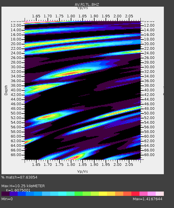
R17L Mt. Peulik Volcano, AVO PLK4, AK, USA - Earthquake Result Viewer
| Earthquake location: |
Mindanao, Philippines |
| Earthquake latitude/longitude: |
6.5/126.8 |
| Earthquake time(UTC): |
2021/08/11 (223) 17:46:14 GMT |
| Earthquake Depth: |
50 km |
| Earthquake Magnitude: |
7.2 Mi |
| Earthquake Catalog/Contributor: |
NEIC PDE/pt |
|
| Network: |
AV Alaska Volcano Observatory |
| Station: |
R17L Mt. Peulik Volcano, AVO PLK4, AK, USA |
| Lat/Lon: |
57.63 N/156.36 W |
| Elevation: |
524 m |
|
| Distance: |
77.5 deg |
| Az: |
32.449 deg |
| Baz: |
262.364 deg |
| Ray Param: |
0.050175942 |
| Estimated Moho Depth: |
10.25 km |
| Estimated Crust Vp/Vs: |
1.61 |
| Assumed Crust Vp: |
6.1 km/s |
| Estimated Crust Vs: |
3.795 km/s |
| Estimated Crust Poisson's Ratio: |
0.18 |
|
| Radial Match: |
87.63854 % |
| Radial Bump: |
400 |
| Transverse Match: |
99.44959 % |
| Transverse Bump: |
91 |
| SOD ConfigId: |
25131211 |
| Insert Time: |
2021-08-25 17:52:18.016 +0000 |
| GWidth: |
2.5 |
| Max Bumps: |
400 |
| Tol: |
0.001 |
|

Signal To Noise
| Channel | StoN | STA | LTA |
| AV:R17L: :BHZ:20210811T17:57:33.500Z | 2.3624234 | 3.9205E-7 | 1.6595247E-7 |
| AV:R17L: :BHN:20210811T17:57:33.500Z | 2.3038313 | 2.614789E-7 | 1.13497414E-7 |
| AV:R17L: :BHE:20210811T17:57:33.500Z | 1.821944 | 4.1936372E-7 | 2.3017377E-7 |
| Arrivals |
| Ps | 1.1 SECOND |
| PpPs | 4.3 SECOND |
| PsPs/PpSs | 5.3 SECOND |


