You are here: Home > Network List > AV - Alaska Volcano Observatory Stations List
> Station OKTU Mount Tulik, Okmok Caldera, Alaska > Earthquake Result Viewer
OKTU Mount Tulik, Okmok Caldera, Alaska - Earthquake Result Viewer
| Earthquake location: |
Mindanao, Philippines |
| Earthquake latitude/longitude: |
6.5/126.8 |
| Earthquake time(UTC): |
2021/08/11 (223) 17:46:14 GMT |
| Earthquake Depth: |
50 km |
| Earthquake Magnitude: |
7.2 Mi |
| Earthquake Catalog/Contributor: |
NEIC PDE/pt |
|
| Network: |
AV Alaska Volcano Observatory |
| Station: |
OKTU Mount Tulik, Okmok Caldera, Alaska |
| Lat/Lon: |
53.38 N/168.04 W |
| Elevation: |
646 m |
|
| Distance: |
70.2 deg |
| Az: |
35.32 deg |
| Baz: |
253.539 deg |
| Ray Param: |
0.055088367 |
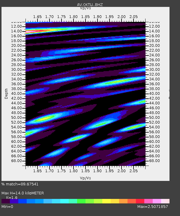
| Estimated Moho Depth: |
14.0 km |
| Estimated Crust Vp/Vs: |
1.60 |
| Assumed Crust Vp: |
5.88 km/s |
| Estimated Crust Vs: |
3.675 km/s |
| Estimated Crust Poisson's Ratio: |
0.18 |
|
| Radial Match: |
89.67541 % |
| Radial Bump: |
400 |
| Transverse Match: |
81.0715 % |
| Transverse Bump: |
400 |
| SOD ConfigId: |
25131211 |
| Insert Time: |
2021-08-25 17:52:45.604 +0000 |
| GWidth: |
2.5 |
| Max Bumps: |
400 |
| Tol: |
0.001 |
|

Signal To Noise
| Channel | StoN | STA | LTA |
| AV:OKTU: :BHZ:20210811T17:56:50.460022Z | 3.3123157 | 6.347911E-7 | 1.9164571E-7 |
| AV:OKTU: :BHN:20210811T17:56:50.460022Z | 1.8047993 | 4.4963843E-7 | 2.4913487E-7 |
| AV:OKTU: :BHE:20210811T17:56:50.460022Z | 1.0724124 | 3.6245734E-7 | 3.3798318E-7 |
| Arrivals |
| Ps | 1.5 SECOND |
| PpPs | 6.0 SECOND |
| PsPs/PpSs | 7.5 SECOND |


