You are here: Home > Network List > CN - Canadian National Seismograph Network Stations List
> Station INK INUVIK, NT > Earthquake Result Viewer
INK INUVIK, NT - Earthquake Result Viewer
| Earthquake location: |
Mindanao, Philippines |
| Earthquake latitude/longitude: |
6.5/126.8 |
| Earthquake time(UTC): |
2021/08/11 (223) 17:46:14 GMT |
| Earthquake Depth: |
50 km |
| Earthquake Magnitude: |
7.2 Mi |
| Earthquake Catalog/Contributor: |
NEIC PDE/pt |
|
| Network: |
CN Canadian National Seismograph Network |
| Station: |
INK INUVIK, NT |
| Lat/Lon: |
68.31 N/133.53 W |
| Elevation: |
44 m |
|
| Distance: |
87.6 deg |
| Az: |
21.517 deg |
| Baz: |
281.396 deg |
| Ray Param: |
0.04312146 |
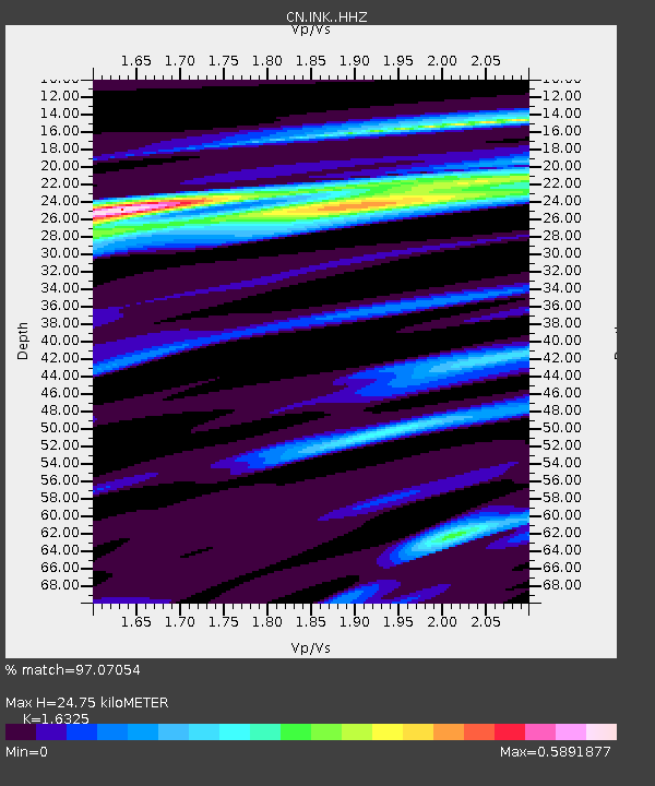
| Estimated Moho Depth: |
24.75 km |
| Estimated Crust Vp/Vs: |
1.63 |
| Assumed Crust Vp: |
6.171 km/s |
| Estimated Crust Vs: |
3.78 km/s |
| Estimated Crust Poisson's Ratio: |
0.20 |
|
| Radial Match: |
97.07054 % |
| Radial Bump: |
369 |
| Transverse Match: |
79.55933 % |
| Transverse Bump: |
400 |
| SOD ConfigId: |
25131211 |
| Insert Time: |
2021-08-25 17:53:07.649 +0000 |
| GWidth: |
2.5 |
| Max Bumps: |
400 |
| Tol: |
0.001 |
|
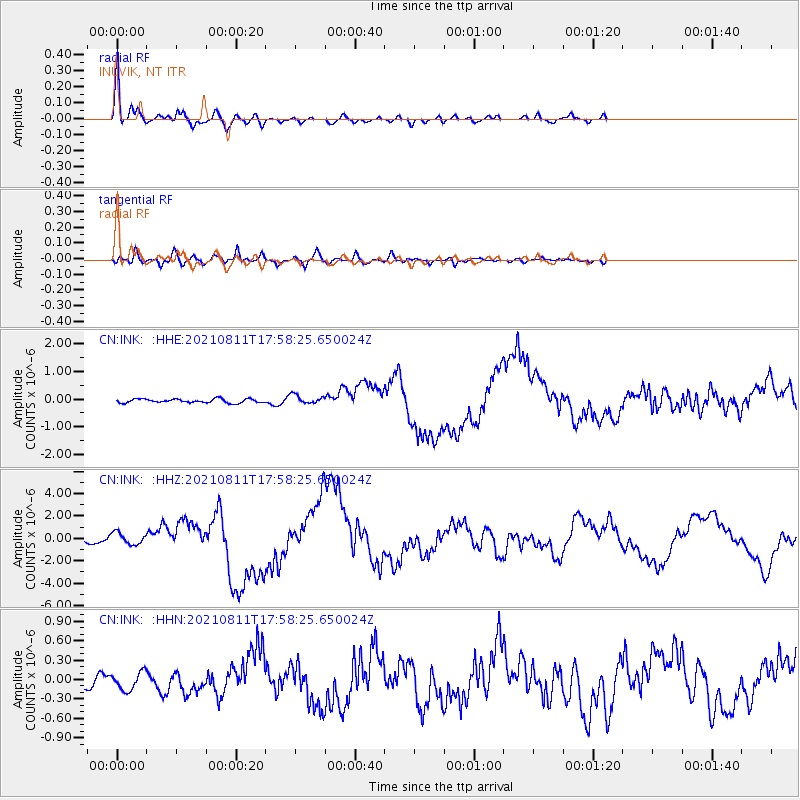
Signal To Noise
| Channel | StoN | STA | LTA |
| CN:INK: :HHZ:20210811T17:58:25.650024Z | 2.6572855 | 5.4050037E-7 | 2.0340322E-7 |
| CN:INK: :HHN:20210811T17:58:25.650024Z | 1.4328419 | 1.3727664E-7 | 9.580725E-8 |
| CN:INK: :HHE:20210811T17:58:25.650024Z | 2.3636062 | 1.6256034E-7 | 6.87764E-8 |
| Arrivals |
| Ps | 2.6 SECOND |
| PpPs | 10 SECOND |
| PsPs/PpSs | 13 SECOND |


