You are here: Home > Network List > NE - New England Seismic Network Stations List
> Station PQI Presque Isle, ME, USA > Earthquake Result Viewer
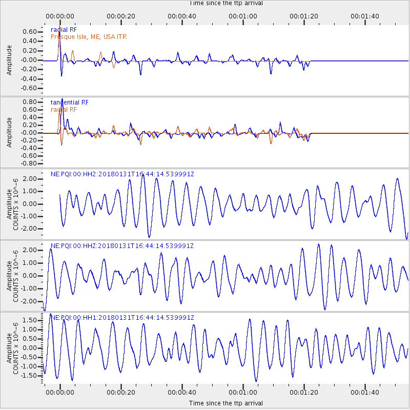
PQI Presque Isle, ME, USA - Earthquake Result Viewer
*The percent match for this event was below the threshold and hence no stack was calculated.
| Earthquake location: |
South Of Panama |
| Earthquake latitude/longitude: |
7.2/-79.6 |
| Earthquake time(UTC): |
2018/01/31 (031) 16:37:06 GMT |
| Earthquake Depth: |
10 km |
| Earthquake Magnitude: |
5.7 Mww |
| Earthquake Catalog/Contributor: |
NEIC PDE/us |
|
| Network: |
NE New England Seismic Network |
| Station: |
PQI Presque Isle, ME, USA |
| Lat/Lon: |
46.67 N/68.02 W |
| Elevation: |
162 m |
|
| Distance: |
40.5 deg |
| Az: |
12.311 deg |
| Baz: |
197.891 deg |
| Ray Param: |
$rayparam |
*The percent match for this event was below the threshold and hence was not used in the summary stack. |
|
| Radial Match: |
45.50622 % |
| Radial Bump: |
330 |
| Transverse Match: |
69.9781 % |
| Transverse Bump: |
328 |
| SOD ConfigId: |
2546091 |
| Insert Time: |
2018-02-14 16:39:02.101 +0000 |
| GWidth: |
2.5 |
| Max Bumps: |
400 |
| Tol: |
0.001 |
|
Signal To Noise
| Channel | StoN | STA | LTA |
| NE:PQI:00:HHZ:20180131T16:44:14.539991Z | 0.62074846 | 1.0339909E-6 | 1.6657164E-6 |
| NE:PQI:00:HH1:20180131T16:44:14.539991Z | 0.8989354 | 1.1248587E-6 | 1.2513233E-6 |
| NE:PQI:00:HH2:20180131T16:44:14.539991Z | 1.9132934 | 1.6365847E-6 | 8.553757E-7 |
| Arrivals |
| Ps | |
| PpPs | |
| PsPs/PpSs | |


