You are here: Home > Network List > YL01 - Himalayan Nepal Tibet Experiment Stations List
> Station BUNG YL.BUNG > Earthquake Result Viewer
BUNG YL.BUNG - Earthquake Result Viewer
| Earthquake location: |
Bali Sea |
| Earthquake latitude/longitude: |
-7.5/115.7 |
| Earthquake time(UTC): |
2002/10/03 (276) 19:05:10 GMT |
| Earthquake Depth: |
316 km |
| Earthquake Magnitude: |
6.0 MB, 6.0 MW, 6.0 MW |
| Earthquake Catalog/Contributor: |
WHDF/NEIC |
|
| Network: |
YL Himalayan Nepal Tibet Experiment |
| Station: |
BUNG YL.BUNG |
| Lat/Lon: |
27.88 N/85.89 E |
| Elevation: |
1191 m |
|
| Distance: |
45.5 deg |
| Az: |
321.927 deg |
| Baz: |
136.316 deg |
| Ray Param: |
0.06994993 |
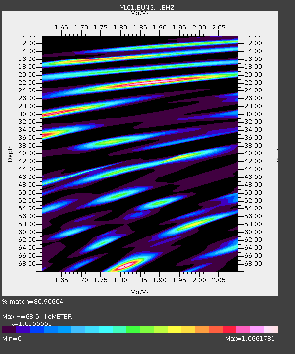
| Estimated Moho Depth: |
68.5 km |
| Estimated Crust Vp/Vs: |
1.81 |
| Assumed Crust Vp: |
6.142 km/s |
| Estimated Crust Vs: |
3.393 km/s |
| Estimated Crust Poisson's Ratio: |
0.28 |
|
| Radial Match: |
80.90604 % |
| Radial Bump: |
400 |
| Transverse Match: |
70.32515 % |
| Transverse Bump: |
400 |
| SOD ConfigId: |
16844 |
| Insert Time: |
2010-02-26 15:52:35.972 +0000 |
| GWidth: |
2.5 |
| Max Bumps: |
400 |
| Tol: |
0.001 |
|
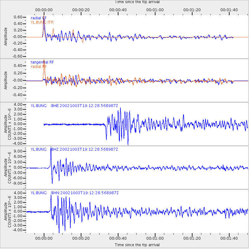
Signal To Noise
| Channel | StoN | STA | LTA |
| YL:BUNG: :BHZ:20021003T19:12:28.568987Z | 69.21766 | 3.4230095E-6 | 4.9452836E-8 |
| YL:BUNG: :BHN:20021003T19:12:28.568987Z | 19.398499 | 9.1624634E-7 | 4.723285E-8 |
| YL:BUNG: :BHE:20021003T19:12:28.568987Z | 16.419613 | 8.1145214E-7 | 4.941969E-8 |
| Arrivals |
| Ps | 9.5 SECOND |
| PpPs | 30 SECOND |
| PsPs/PpSs | 39 SECOND |


