You are here: Home > Network List > NM - Cooperative New Madrid Seismic Network Stations List
> Station SIUC Carbondale, IL > Earthquake Result Viewer
SIUC Carbondale, IL - Earthquake Result Viewer
| Earthquake location: |
Off Coast Of Oregon |
| Earthquake latitude/longitude: |
44.5/-130.1 |
| Earthquake time(UTC): |
2000/06/02 (154) 11:13:49 GMT |
| Earthquake Depth: |
10 km |
| Earthquake Magnitude: |
5.8 MB, 6.0 MS, 6.2 MW, 6.2 MW |
| Earthquake Catalog/Contributor: |
WHDF/NEIC |
|
| Network: |
NM Cooperative New Madrid Seismic Network |
| Station: |
SIUC Carbondale, IL |
| Lat/Lon: |
37.71 N/89.22 W |
| Elevation: |
120 m |
|
| Distance: |
31.3 deg |
| Az: |
88.147 deg |
| Baz: |
295.622 deg |
| Ray Param: |
0.07911244 |
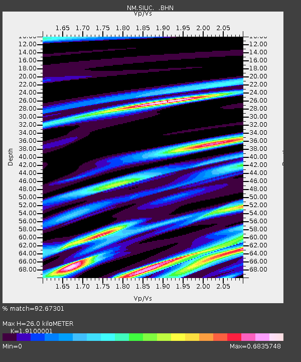
| Estimated Moho Depth: |
26.0 km |
| Estimated Crust Vp/Vs: |
1.91 |
| Assumed Crust Vp: |
6.444 km/s |
| Estimated Crust Vs: |
3.374 km/s |
| Estimated Crust Poisson's Ratio: |
0.31 |
|
| Radial Match: |
92.67301 % |
| Radial Bump: |
334 |
| Transverse Match: |
71.91938 % |
| Transverse Bump: |
400 |
| SOD ConfigId: |
3744 |
| Insert Time: |
2010-03-09 11:28:32.850 +0000 |
| GWidth: |
2.5 |
| Max Bumps: |
400 |
| Tol: |
0.001 |
|

Signal To Noise
| Channel | StoN | STA | LTA |
| NM:SIUC: :BHN:20000602T11:19:38.661006Z | 3.5396183 | 4.140836E-7 | 1.1698538E-7 |
| NM:SIUC: :BHE:20000602T11:19:38.661006Z | 5.780139 | 6.950819E-7 | 1.2025349E-7 |
| NM:SIUC: :BHZ:20000602T11:19:38.661006Z | 5.882864 | 1.1281354E-6 | 1.9176636E-7 |
| Arrivals |
| Ps | 4.0 SECOND |
| PpPs | 11 SECOND |
| PsPs/PpSs | 15 SECOND |


