You are here: Home > Network List > AV - Alaska Volcano Observatory Stations List
> Station SPCR Ckakachatna River, Mount Spurr, Alaska > Earthquake Result Viewer
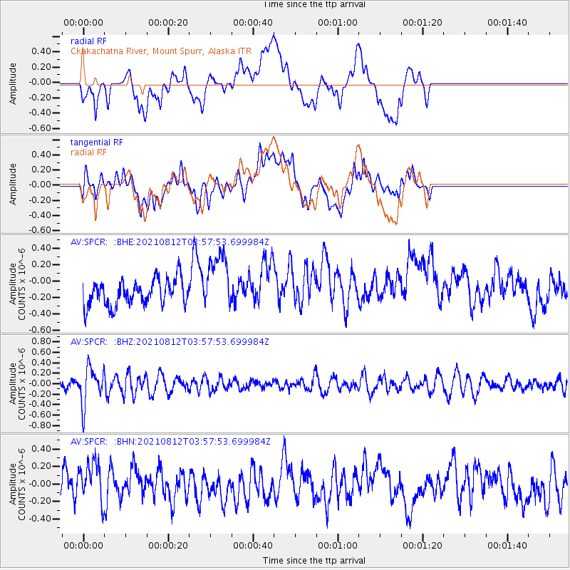
SPCR Ckakachatna River, Mount Spurr, Alaska - Earthquake Result Viewer
*The percent match for this event was below the threshold and hence no stack was calculated.
| Earthquake location: |
Fiji Islands Region |
| Earthquake latitude/longitude: |
-18.3/-177.9 |
| Earthquake time(UTC): |
2021/08/12 (224) 03:47:00 GMT |
| Earthquake Depth: |
520 km |
| Earthquake Magnitude: |
5.5 mww |
| Earthquake Catalog/Contributor: |
NEIC PDE/us |
|
| Network: |
AV Alaska Volcano Observatory |
| Station: |
SPCR Ckakachatna River, Mount Spurr, Alaska |
| Lat/Lon: |
61.20 N/152.21 W |
| Elevation: |
984 m |
|
| Distance: |
81.9 deg |
| Az: |
12.244 deg |
| Baz: |
204.582 deg |
| Ray Param: |
$rayparam |
*The percent match for this event was below the threshold and hence was not used in the summary stack. |
|
| Radial Match: |
47.058624 % |
| Radial Bump: |
400 |
| Transverse Match: |
47.84831 % |
| Transverse Bump: |
400 |
| SOD ConfigId: |
25131211 |
| Insert Time: |
2021-08-26 03:51:54.018 +0000 |
| GWidth: |
2.5 |
| Max Bumps: |
400 |
| Tol: |
0.001 |
|
Signal To Noise
| Channel | StoN | STA | LTA |
| AV:SPCR: :BHZ:20210812T03:57:53.699984Z | 2.8951373 | 3.6111106E-7 | 1.247302E-7 |
| AV:SPCR: :BHN:20210812T03:57:53.699984Z | 1.7444609 | 2.5718032E-7 | 1.4742682E-7 |
| AV:SPCR: :BHE:20210812T03:57:53.699984Z | 2.3764076 | 3.7111894E-7 | 1.5616806E-7 |
| Arrivals |
| Ps | |
| PpPs | |
| PsPs/PpSs | |


