You are here: Home > Network List > NM - Cooperative New Madrid Seismic Network Stations List
> Station SIUC Carbondale, IL > Earthquake Result Viewer
SIUC Carbondale, IL - Earthquake Result Viewer
| Earthquake location: |
Hokkaido, Japan Region |
| Earthquake latitude/longitude: |
41.0/142.3 |
| Earthquake time(UTC): |
2001/08/13 (225) 20:11:23 GMT |
| Earthquake Depth: |
38 km |
| Earthquake Magnitude: |
6.0 MB, 6.3 MS, 6.4 MW, 6.3 ME |
| Earthquake Catalog/Contributor: |
WHDF/NEIC |
|
| Network: |
NM Cooperative New Madrid Seismic Network |
| Station: |
SIUC Carbondale, IL |
| Lat/Lon: |
37.71 N/89.22 W |
| Elevation: |
120 m |
|
| Distance: |
88.6 deg |
| Az: |
38.394 deg |
| Baz: |
323.677 deg |
| Ray Param: |
0.04244892 |
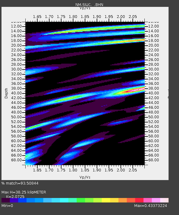
| Estimated Moho Depth: |
38.25 km |
| Estimated Crust Vp/Vs: |
2.07 |
| Assumed Crust Vp: |
6.444 km/s |
| Estimated Crust Vs: |
3.109 km/s |
| Estimated Crust Poisson's Ratio: |
0.35 |
|
| Radial Match: |
93.50844 % |
| Radial Bump: |
400 |
| Transverse Match: |
85.213135 % |
| Transverse Bump: |
400 |
| SOD ConfigId: |
20082 |
| Insert Time: |
2010-03-09 11:29:04.884 +0000 |
| GWidth: |
2.5 |
| Max Bumps: |
400 |
| Tol: |
0.001 |
|

Signal To Noise
| Channel | StoN | STA | LTA |
| NM:SIUC: :BHN:20010813T20:23:40.959021Z | 2.1460125 | 5.992063E-7 | 2.7921845E-7 |
| NM:SIUC: :BHE:20010813T20:23:40.959021Z | 1.3309871 | 3.379637E-7 | 2.539196E-7 |
| NM:SIUC: :BHZ:20010813T20:23:40.959021Z | 11.0528345 | 1.2511285E-6 | 1.1319526E-7 |
| Arrivals |
| Ps | 6.5 SECOND |
| PpPs | 18 SECOND |
| PsPs/PpSs | 24 SECOND |


