You are here: Home > Network List > TA - USArray Transportable Network (new EarthScope stations) Stations List
> Station TUL3 Leonard, OK, USA > Earthquake Result Viewer
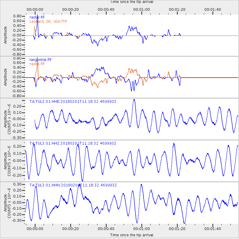
TUL3 Leonard, OK, USA - Earthquake Result Viewer
*The percent match for this event was below the threshold and hence no stack was calculated.
| Earthquake location: |
Fiji Islands Region |
| Earthquake latitude/longitude: |
-16.6/-177.4 |
| Earthquake time(UTC): |
2018/02/01 (032) 11:05:50 GMT |
| Earthquake Depth: |
10 km |
| Earthquake Magnitude: |
6.0 Mww |
| Earthquake Catalog/Contributor: |
NEIC PDE/us |
|
| Network: |
TA USArray Transportable Network (new EarthScope stations) |
| Station: |
TUL3 Leonard, OK, USA |
| Lat/Lon: |
35.91 N/95.79 W |
| Elevation: |
265 m |
|
| Distance: |
93.0 deg |
| Az: |
53.534 deg |
| Baz: |
251.743 deg |
| Ray Param: |
$rayparam |
*The percent match for this event was below the threshold and hence was not used in the summary stack. |
|
| Radial Match: |
65.08696 % |
| Radial Bump: |
400 |
| Transverse Match: |
42.021065 % |
| Transverse Bump: |
400 |
| SOD ConfigId: |
2546091 |
| Insert Time: |
2018-02-15 11:08:03.661 +0000 |
| GWidth: |
2.5 |
| Max Bumps: |
400 |
| Tol: |
0.001 |
|
Signal To Noise
| Channel | StoN | STA | LTA |
| TA:TUL3:01:HHZ:20180201T11:18:32.469993Z | 1.8478667 | 1.4358451E-7 | 7.770286E-8 |
| TA:TUL3:01:HHN:20180201T11:18:32.469993Z | 1.7044605 | 1.819249E-7 | 1.06734596E-7 |
| TA:TUL3:01:HHE:20180201T11:18:32.469993Z | 0.9313522 | 7.3930224E-8 | 7.937945E-8 |
| Arrivals |
| Ps | |
| PpPs | |
| PsPs/PpSs | |


