You are here: Home > Network List > US - United States National Seismic Network Stations List
> Station HLID Hailey, Idaho, USA > Earthquake Result Viewer
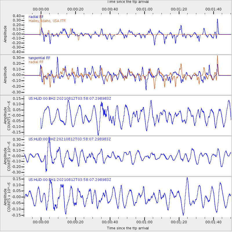
HLID Hailey, Idaho, USA - Earthquake Result Viewer
*The percent match for this event was below the threshold and hence no stack was calculated.
| Earthquake location: |
Fiji Islands Region |
| Earthquake latitude/longitude: |
-18.3/-177.9 |
| Earthquake time(UTC): |
2021/08/12 (224) 03:47:00 GMT |
| Earthquake Depth: |
520 km |
| Earthquake Magnitude: |
5.5 mww |
| Earthquake Catalog/Contributor: |
NEIC PDE/us |
|
| Network: |
US United States National Seismic Network |
| Station: |
HLID Hailey, Idaho, USA |
| Lat/Lon: |
43.56 N/114.41 W |
| Elevation: |
1772 m |
|
| Distance: |
84.6 deg |
| Az: |
40.796 deg |
| Baz: |
238.615 deg |
| Ray Param: |
$rayparam |
*The percent match for this event was below the threshold and hence was not used in the summary stack. |
|
| Radial Match: |
62.670536 % |
| Radial Bump: |
400 |
| Transverse Match: |
66.101494 % |
| Transverse Bump: |
400 |
| SOD ConfigId: |
25131211 |
| Insert Time: |
2021-08-26 04:03:01.763 +0000 |
| GWidth: |
2.5 |
| Max Bumps: |
400 |
| Tol: |
0.001 |
|
Signal To Noise
| Channel | StoN | STA | LTA |
| US:HLID:00:BHZ:20210812T03:58:07.298983Z | 2.654042 | 1.54992E-7 | 5.839847E-8 |
| US:HLID:00:BH1:20210812T03:58:07.298983Z | 0.7314001 | 4.5907246E-8 | 6.2766254E-8 |
| US:HLID:00:BH2:20210812T03:58:07.298983Z | 1.343462 | 8.576618E-8 | 6.383968E-8 |
| Arrivals |
| Ps | |
| PpPs | |
| PsPs/PpSs | |


