You are here: Home > Network List > US - United States National Seismic Network Stations List
> Station MSO Missoula, Montana, USA > Earthquake Result Viewer
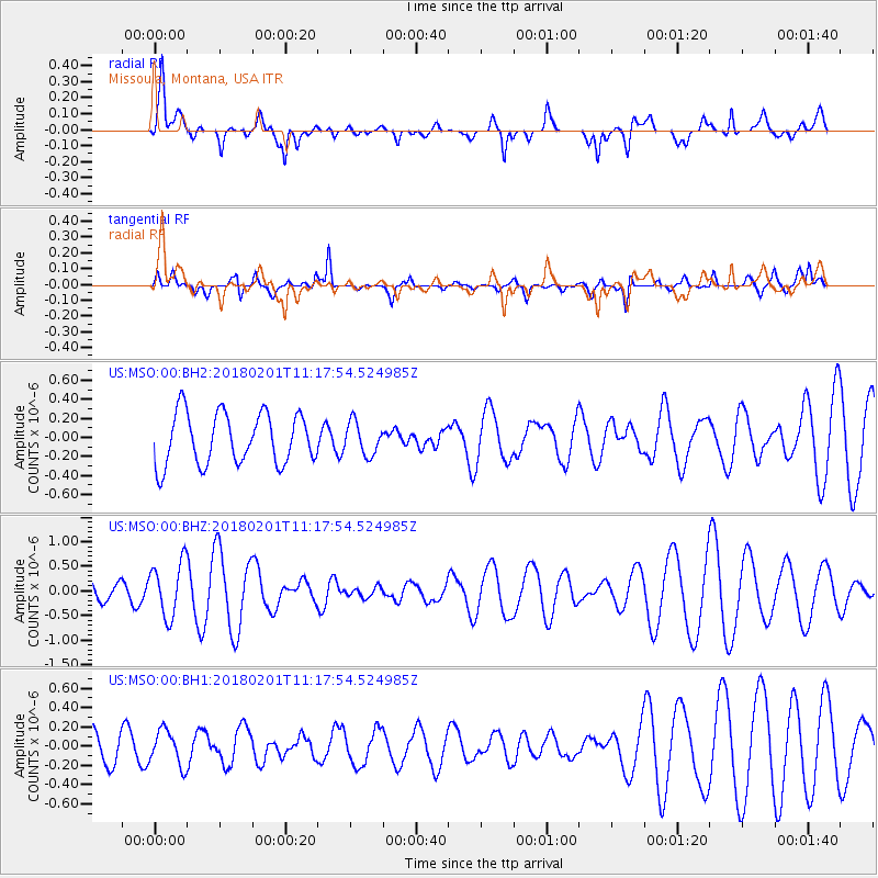
MSO Missoula, Montana, USA - Earthquake Result Viewer
*The percent match for this event was below the threshold and hence no stack was calculated.
| Earthquake location: |
Fiji Islands Region |
| Earthquake latitude/longitude: |
-16.6/-177.4 |
| Earthquake time(UTC): |
2018/02/01 (032) 11:05:50 GMT |
| Earthquake Depth: |
10 km |
| Earthquake Magnitude: |
6.0 Mww |
| Earthquake Catalog/Contributor: |
NEIC PDE/us |
|
| Network: |
US United States National Seismic Network |
| Station: |
MSO Missoula, Montana, USA |
| Lat/Lon: |
46.83 N/113.94 W |
| Elevation: |
1264 m |
|
| Distance: |
85.0 deg |
| Az: |
38.067 deg |
| Baz: |
239.412 deg |
| Ray Param: |
$rayparam |
*The percent match for this event was below the threshold and hence was not used in the summary stack. |
|
| Radial Match: |
60.13829 % |
| Radial Bump: |
400 |
| Transverse Match: |
81.67057 % |
| Transverse Bump: |
399 |
| SOD ConfigId: |
2546091 |
| Insert Time: |
2018-02-15 11:08:46.176 +0000 |
| GWidth: |
2.5 |
| Max Bumps: |
400 |
| Tol: |
0.001 |
|
Signal To Noise
| Channel | StoN | STA | LTA |
| US:MSO:00:BHZ:20180201T11:17:54.524985Z | 1.9727794 | 5.5440654E-7 | 2.8102812E-7 |
| US:MSO:00:BH1:20180201T11:17:54.524985Z | 1.2514526 | 1.8163587E-7 | 1.4514004E-7 |
| US:MSO:00:BH2:20180201T11:17:54.524985Z | 0.6329785 | 1.70075E-7 | 2.6869E-7 |
| Arrivals |
| Ps | |
| PpPs | |
| PsPs/PpSs | |


