You are here: Home > Network List > WY - Yellowstone Wyoming Seismic Network Stations List
> Station YHH Holmes Hill, YNP, WY, USA > Earthquake Result Viewer
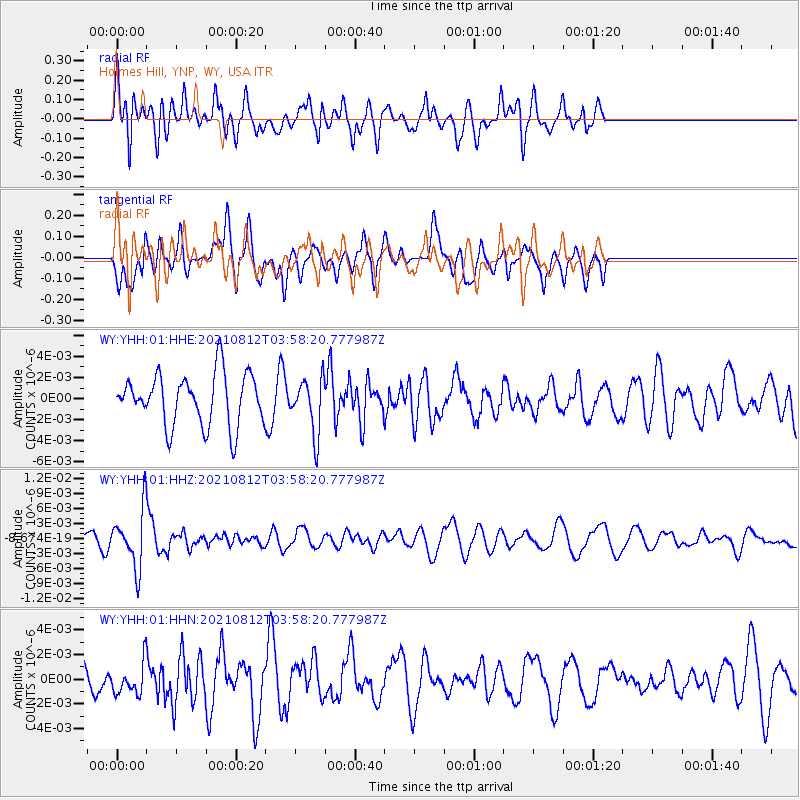
YHH Holmes Hill, YNP, WY, USA - Earthquake Result Viewer
*The percent match for this event was below the threshold and hence no stack was calculated.
| Earthquake location: |
Fiji Islands Region |
| Earthquake latitude/longitude: |
-18.3/-177.9 |
| Earthquake time(UTC): |
2021/08/12 (224) 03:47:00 GMT |
| Earthquake Depth: |
520 km |
| Earthquake Magnitude: |
5.5 mww |
| Earthquake Catalog/Contributor: |
NEIC PDE/us |
|
| Network: |
WY Yellowstone Wyoming Seismic Network |
| Station: |
YHH Holmes Hill, YNP, WY, USA |
| Lat/Lon: |
44.79 N/110.85 W |
| Elevation: |
2717 m |
|
| Distance: |
87.5 deg |
| Az: |
41.024 deg |
| Baz: |
241.106 deg |
| Ray Param: |
$rayparam |
*The percent match for this event was below the threshold and hence was not used in the summary stack. |
|
| Radial Match: |
52.66517 % |
| Radial Bump: |
400 |
| Transverse Match: |
51.113537 % |
| Transverse Bump: |
367 |
| SOD ConfigId: |
25131211 |
| Insert Time: |
2021-08-26 04:05:01.662 +0000 |
| GWidth: |
2.5 |
| Max Bumps: |
400 |
| Tol: |
0.001 |
|
Signal To Noise
| Channel | StoN | STA | LTA |
| WY:YHH:01:HHZ:20210812T03:58:20.777987Z | 3.5072546 | 5.609171E-9 | 1.5993054E-9 |
| WY:YHH:01:HHN:20210812T03:58:20.777987Z | 0.7576698 | 1.2373678E-9 | 1.6331227E-9 |
| WY:YHH:01:HHE:20210812T03:58:20.777987Z | 1.0614915 | 2.5801197E-9 | 2.430655E-9 |
| Arrivals |
| Ps | |
| PpPs | |
| PsPs/PpSs | |


