You are here: Home > Network List > YL01 - Himalayan Nepal Tibet Experiment Stations List
> Station BUNG YL.BUNG > Earthquake Result Viewer
BUNG YL.BUNG - Earthquake Result Viewer
| Earthquake location: |
Near East Coast Of Kamchatka |
| Earthquake latitude/longitude: |
52.0/157.3 |
| Earthquake time(UTC): |
2002/10/16 (289) 10:12:21 GMT |
| Earthquake Depth: |
102 km |
| Earthquake Magnitude: |
6.1 MB, 6.2 MW, 6.2 MW |
| Earthquake Catalog/Contributor: |
WHDF/NEIC |
|
| Network: |
YL Himalayan Nepal Tibet Experiment |
| Station: |
BUNG YL.BUNG |
| Lat/Lon: |
27.88 N/85.89 E |
| Elevation: |
1191 m |
|
| Distance: |
57.3 deg |
| Az: |
274.527 deg |
| Baz: |
44.181 deg |
| Ray Param: |
0.06326365 |
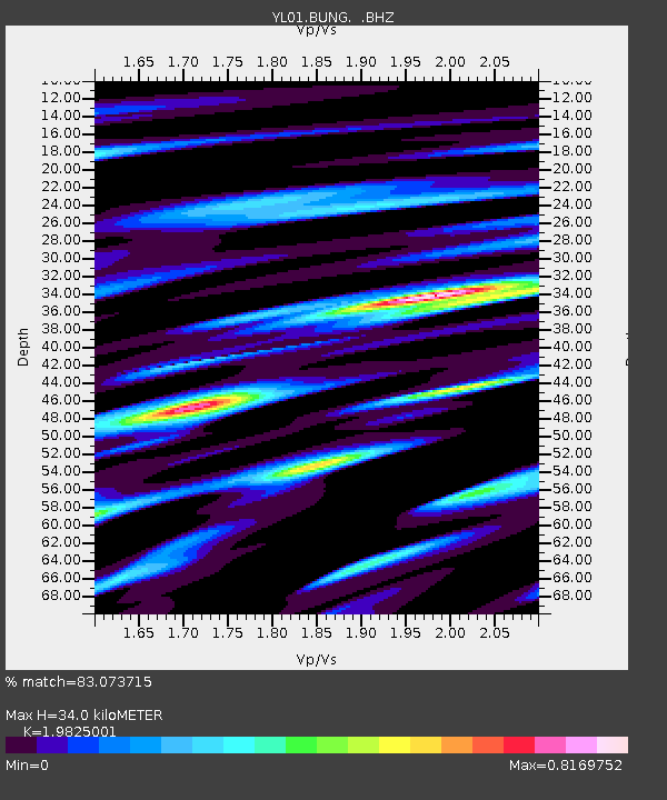
| Estimated Moho Depth: |
34.0 km |
| Estimated Crust Vp/Vs: |
1.98 |
| Assumed Crust Vp: |
6.142 km/s |
| Estimated Crust Vs: |
3.098 km/s |
| Estimated Crust Poisson's Ratio: |
0.33 |
|
| Radial Match: |
83.073715 % |
| Radial Bump: |
400 |
| Transverse Match: |
74.81199 % |
| Transverse Bump: |
400 |
| SOD ConfigId: |
16844 |
| Insert Time: |
2010-02-26 15:52:42.972 +0000 |
| GWidth: |
2.5 |
| Max Bumps: |
400 |
| Tol: |
0.001 |
|

Signal To Noise
| Channel | StoN | STA | LTA |
| YL:BUNG: :BHZ:20021016T10:21:28.101021Z | 33.41634 | 2.0246684E-6 | 6.058917E-8 |
| YL:BUNG: :BHN:20021016T10:21:28.101997Z | 18.153532 | 7.857953E-7 | 4.3286086E-8 |
| YL:BUNG: :BHE:20021016T10:21:28.101997Z | 6.0500135 | 6.529832E-7 | 1.07930866E-7 |
| Arrivals |
| Ps | 5.7 SECOND |
| PpPs | 16 SECOND |
| PsPs/PpSs | 22 SECOND |


