You are here: Home > Network List > NM - Cooperative New Madrid Seismic Network Stations List
> Station SIUC Carbondale, IL > Earthquake Result Viewer
SIUC Carbondale, IL - Earthquake Result Viewer
| Earthquake location: |
Leeward Islands |
| Earthquake latitude/longitude: |
15.7/-61.7 |
| Earthquake time(UTC): |
2004/11/21 (326) 11:41:07 GMT |
| Earthquake Depth: |
14 km |
| Earthquake Magnitude: |
6.3 MB, 6.1 MS, 6.3 MW, 6.3 MW |
| Earthquake Catalog/Contributor: |
WHDF/NEIC |
|
| Network: |
NM Cooperative New Madrid Seismic Network |
| Station: |
SIUC Carbondale, IL |
| Lat/Lon: |
37.71 N/89.22 W |
| Elevation: |
120 m |
|
| Distance: |
32.7 deg |
| Az: |
317.364 deg |
| Baz: |
124.642 deg |
| Ray Param: |
0.07851526 |
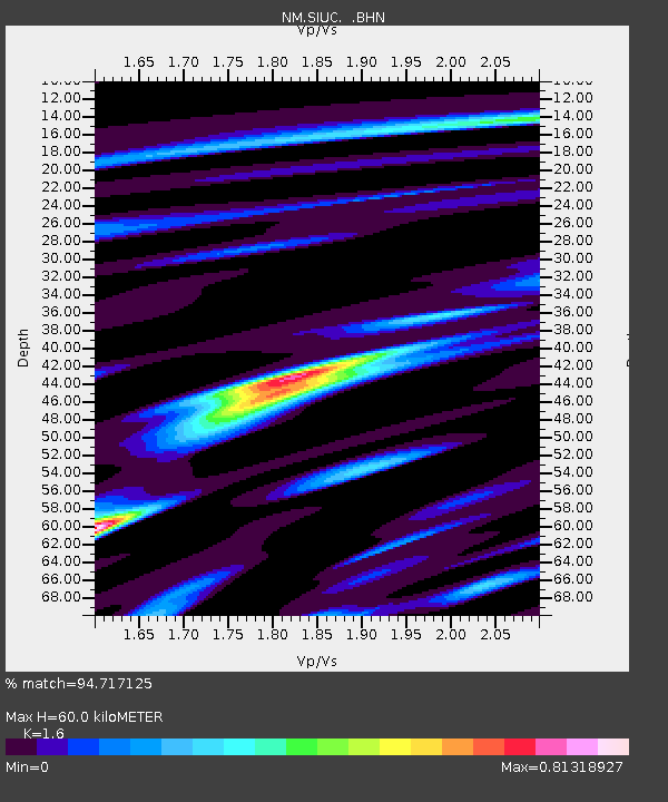
| Estimated Moho Depth: |
60.0 km |
| Estimated Crust Vp/Vs: |
1.60 |
| Assumed Crust Vp: |
6.444 km/s |
| Estimated Crust Vs: |
4.027 km/s |
| Estimated Crust Poisson's Ratio: |
0.18 |
|
| Radial Match: |
94.717125 % |
| Radial Bump: |
349 |
| Transverse Match: |
87.33221 % |
| Transverse Bump: |
400 |
| SOD ConfigId: |
2459 |
| Insert Time: |
2010-03-09 11:29:55.435 +0000 |
| GWidth: |
2.5 |
| Max Bumps: |
400 |
| Tol: |
0.001 |
|

Signal To Noise
| Channel | StoN | STA | LTA |
| NM:SIUC: :BHN:20041121T11:47:09.27001Z | 3.8554482 | 1.3057477E-6 | 3.3867596E-7 |
| NM:SIUC: :BHE:20041121T11:47:09.27001Z | 4.768449 | 1.598476E-6 | 3.352193E-7 |
| NM:SIUC: :BHZ:20041121T11:47:09.27001Z | 13.649587 | 2.7217966E-6 | 1.9940505E-7 |
| Arrivals |
| Ps | 6.1 SECOND |
| PpPs | 22 SECOND |
| PsPs/PpSs | 28 SECOND |


