You are here: Home > Network List > GS - US Geological Survey Networks Stations List
> Station PR02 PR02, Guayanilla > Earthquake Result Viewer
PR02 PR02, Guayanilla - Earthquake Result Viewer
| Earthquake location: |
South Sandwich Islands Region |
| Earthquake latitude/longitude: |
-57.4/-24.8 |
| Earthquake time(UTC): |
2021/08/12 (224) 18:32:51 GMT |
| Earthquake Depth: |
78 km |
| Earthquake Magnitude: |
7.6 Mi |
| Earthquake Catalog/Contributor: |
NEIC PDE/at |
|
| Network: |
GS US Geological Survey Networks |
| Station: |
PR02 PR02, Guayanilla |
| Lat/Lon: |
18.01 N/66.77 W |
| Elevation: |
3.0 m |
|
| Distance: |
82.8 deg |
| Az: |
320.106 deg |
| Baz: |
158.601 deg |
| Ray Param: |
0.046450187 |
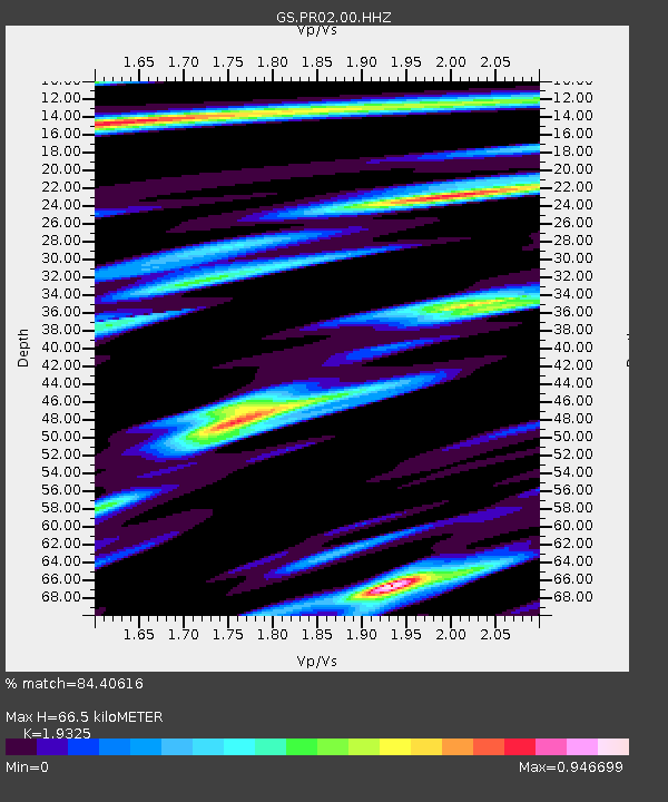
| Estimated Moho Depth: |
66.5 km |
| Estimated Crust Vp/Vs: |
1.93 |
| Assumed Crust Vp: |
5.14 km/s |
| Estimated Crust Vs: |
2.66 km/s |
| Estimated Crust Poisson's Ratio: |
0.32 |
|
| Radial Match: |
84.40616 % |
| Radial Bump: |
400 |
| Transverse Match: |
79.502625 % |
| Transverse Bump: |
400 |
| SOD ConfigId: |
25131211 |
| Insert Time: |
2021-08-26 18:34:55.930 +0000 |
| GWidth: |
2.5 |
| Max Bumps: |
400 |
| Tol: |
0.001 |
|

Signal To Noise
| Channel | StoN | STA | LTA |
| GS:PR02:00:HHZ:20210812T18:44:35.758972Z | 0.7363813 | 3.4885875E-7 | 4.737474E-7 |
| GS:PR02:00:HH1:20210812T18:44:35.758972Z | 1.1796578 | 9.1857896E-7 | 7.7868253E-7 |
| GS:PR02:00:HH2:20210812T18:44:35.758972Z | 1.336243 | 8.263044E-7 | 6.183788E-7 |
| Arrivals |
| Ps | 12 SECOND |
| PpPs | 37 SECOND |
| PsPs/PpSs | 50 SECOND |


