You are here: Home > Network List > IU - Global Seismograph Network (GSN - IRIS/USGS) Stations List
> Station NWAO Narrogin, Australia > Earthquake Result Viewer
NWAO Narrogin, Australia - Earthquake Result Viewer
| Earthquake location: |
Southern Molucca Sea |
| Earthquake latitude/longitude: |
-0.2/125.2 |
| Earthquake time(UTC): |
2018/02/02 (033) 00:20:42 GMT |
| Earthquake Depth: |
38 km |
| Earthquake Magnitude: |
5.5 Mww |
| Earthquake Catalog/Contributor: |
NEIC PDE/us |
|
| Network: |
IU Global Seismograph Network (GSN - IRIS/USGS) |
| Station: |
NWAO Narrogin, Australia |
| Lat/Lon: |
32.93 S/117.24 E |
| Elevation: |
380 m |
|
| Distance: |
33.4 deg |
| Az: |
192.203 deg |
| Baz: |
14.556 deg |
| Ray Param: |
0.07817628 |
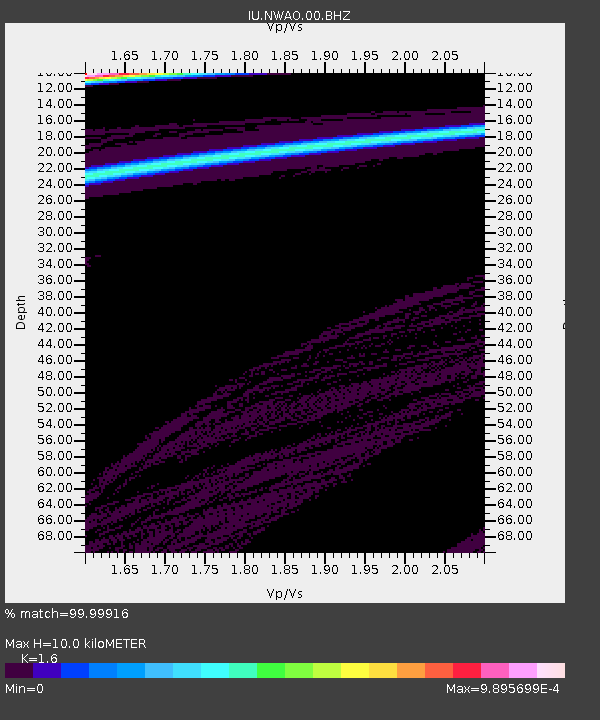
| Estimated Moho Depth: |
10.0 km |
| Estimated Crust Vp/Vs: |
1.60 |
| Assumed Crust Vp: |
6.419 km/s |
| Estimated Crust Vs: |
4.012 km/s |
| Estimated Crust Poisson's Ratio: |
0.18 |
|
| Radial Match: |
99.99916 % |
| Radial Bump: |
3 |
| Transverse Match: |
99.99889 % |
| Transverse Bump: |
3 |
| SOD ConfigId: |
2546091 |
| Insert Time: |
2018-02-16 00:21:33.387 +0000 |
| GWidth: |
2.5 |
| Max Bumps: |
400 |
| Tol: |
0.001 |
|
Signal To Noise
| Channel | StoN | STA | LTA |
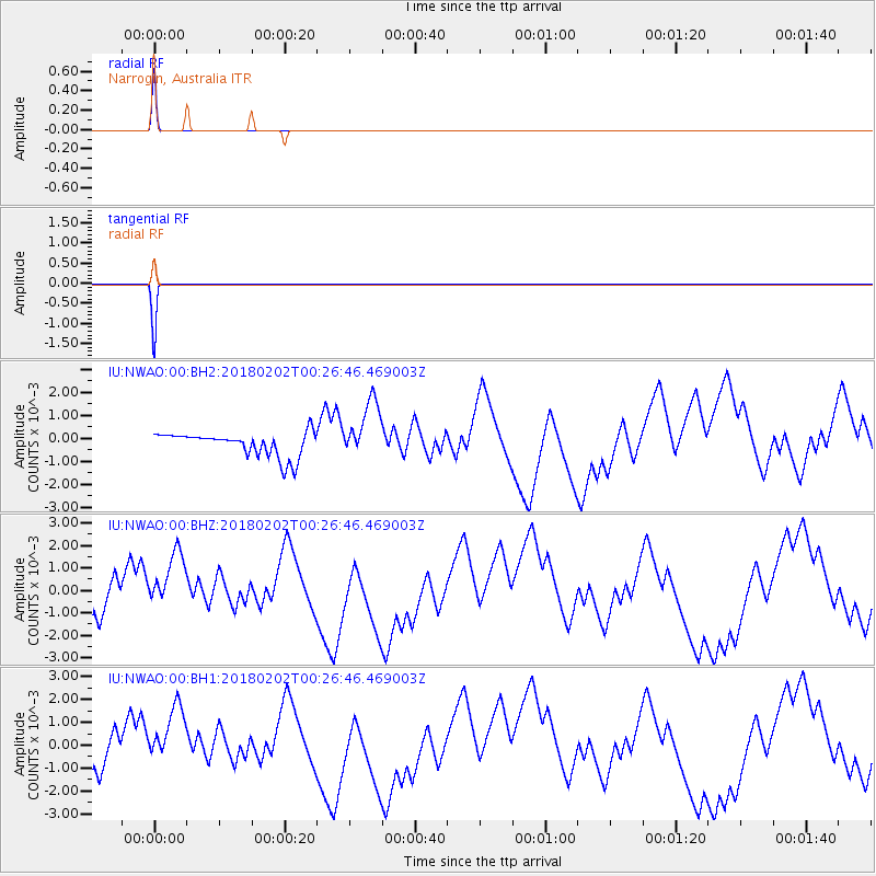
| IU:NWAO:00:BHZ:20180202T00:26:46.469003Z | 2.4585888 | 0.0013144203 | 5.346238E-4 |
| IU:NWAO:00:BH1:20180202T00:26:46.469003Z | 2.4584398 | 0.0013072385 | 5.31735E-4 |
| IU:NWAO:00:BH2:20180202T00:26:46.469003Z | 2.4592097 | 0.0012867615 | 5.232419E-4 |
| Arrivals |
| Ps | 1.0 SECOND |
| PpPs | 3.7 SECOND |
| PsPs/PpSs | 4.7 SECOND |


