You are here: Home > Network List > G - GEOSCOPE Stations List
> Station CAN Canberra, Australia > Earthquake Result Viewer
CAN Canberra, Australia - Earthquake Result Viewer
| Earthquake location: |
South Sandwich Islands Region |
| Earthquake latitude/longitude: |
-58.4/-25.3 |
| Earthquake time(UTC): |
2021/08/12 (224) 18:35:20 GMT |
| Earthquake Depth: |
48 km |
| Earthquake Magnitude: |
8.1 Mww |
| Earthquake Catalog/Contributor: |
NEIC PDE/us |
|
| Network: |
G GEOSCOPE |
| Station: |
CAN Canberra, Australia |
| Lat/Lon: |
35.32 S/149.00 E |
| Elevation: |
650 m |
|
| Distance: |
86.5 deg |
| Az: |
175.349 deg |
| Baz: |
182.992 deg |
| Ray Param: |
0.043932937 |
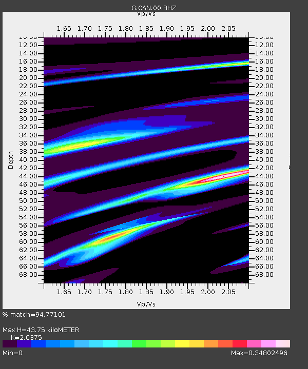
| Estimated Moho Depth: |
43.75 km |
| Estimated Crust Vp/Vs: |
2.04 |
| Assumed Crust Vp: |
6.633 km/s |
| Estimated Crust Vs: |
3.256 km/s |
| Estimated Crust Poisson's Ratio: |
0.34 |
|
| Radial Match: |
94.77101 % |
| Radial Bump: |
272 |
| Transverse Match: |
64.76468 % |
| Transverse Bump: |
400 |
| SOD ConfigId: |
25131211 |
| Insert Time: |
2021-08-26 18:38:48.842 +0000 |
| GWidth: |
2.5 |
| Max Bumps: |
400 |
| Tol: |
0.001 |
|
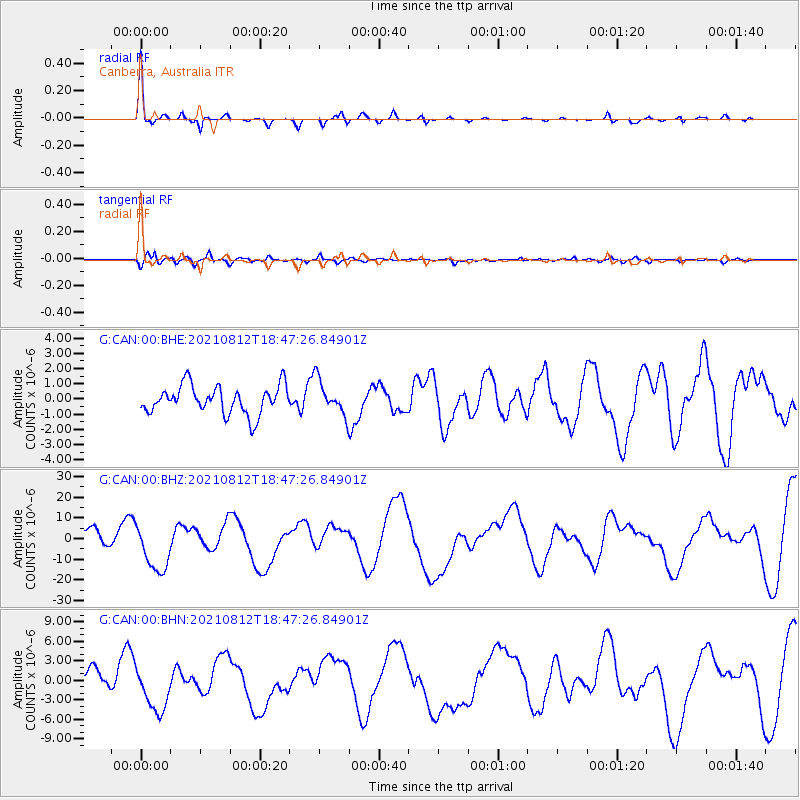
Signal To Noise
| Channel | StoN | STA | LTA |
| G:CAN:00:BHZ:20210812T18:47:26.84901Z | 2.2538545 | 1.1509665E-5 | 5.106658E-6 |
| G:CAN:00:BHN:20210812T18:47:26.84901Z | 1.6348097 | 3.4397763E-6 | 2.1040835E-6 |
| G:CAN:00:BHE:20210812T18:47:26.84901Z | 1.2261996 | 1.1366798E-6 | 9.2699406E-7 |
| Arrivals |
| Ps | 7.0 SECOND |
| PpPs | 20 SECOND |
| PsPs/PpSs | 27 SECOND |


