You are here: Home > Network List > GS - US Geological Survey Networks Stations List
> Station PR01 PR01, Lajas > Earthquake Result Viewer
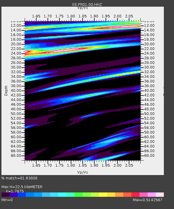
PR01 PR01, Lajas - Earthquake Result Viewer
| Earthquake location: |
South Sandwich Islands Region |
| Earthquake latitude/longitude: |
-58.4/-25.3 |
| Earthquake time(UTC): |
2021/08/12 (224) 18:35:20 GMT |
| Earthquake Depth: |
48 km |
| Earthquake Magnitude: |
8.1 Mww |
| Earthquake Catalog/Contributor: |
NEIC PDE/us |
|
| Network: |
GS US Geological Survey Networks |
| Station: |
PR01 PR01, Lajas |
| Lat/Lon: |
18.03 N/67.07 W |
| Elevation: |
33 m |
|
| Distance: |
83.6 deg |
| Az: |
320.391 deg |
| Baz: |
159.35 deg |
| Ray Param: |
0.046014197 |
| Estimated Moho Depth: |
22.5 km |
| Estimated Crust Vp/Vs: |
1.77 |
| Assumed Crust Vp: |
5.14 km/s |
| Estimated Crust Vs: |
2.908 km/s |
| Estimated Crust Poisson's Ratio: |
0.26 |
|
| Radial Match: |
81.93808 % |
| Radial Bump: |
400 |
| Transverse Match: |
64.33556 % |
| Transverse Bump: |
400 |
| SOD ConfigId: |
25131211 |
| Insert Time: |
2021-08-26 18:39:01.594 +0000 |
| GWidth: |
2.5 |
| Max Bumps: |
400 |
| Tol: |
0.001 |
|

Signal To Noise
| Channel | StoN | STA | LTA |
| GS:PR01:00:HHZ:20210812T18:47:12.229015Z | 0.35430467 | 1.0389526E-6 | 2.9323708E-6 |
| GS:PR01:00:HH1:20210812T18:47:12.229015Z | 1.0458895 | 2.6248547E-6 | 2.5096865E-6 |
| GS:PR01:00:HH2:20210812T18:47:12.229015Z | 0.51009303 | 1.3444497E-6 | 2.6356952E-6 |
| Arrivals |
| Ps | 3.4 SECOND |
| PpPs | 12 SECOND |
| PsPs/PpSs | 15 SECOND |


