You are here: Home > Network List > GT - Global Telemetered Seismograph Network (USAF/USGS) Stations List
> Station BOSA Boshof, South Africa > Earthquake Result Viewer
BOSA Boshof, South Africa - Earthquake Result Viewer
| Earthquake location: |
South Sandwich Islands Region |
| Earthquake latitude/longitude: |
-57.0/-25.1 |
| Earthquake time(UTC): |
2021/08/12 (224) 18:49:50 GMT |
| Earthquake Depth: |
20 km |
| Earthquake Magnitude: |
5.9 mb |
| Earthquake Catalog/Contributor: |
NEIC PDE/us |
|
| Network: |
GT Global Telemetered Seismograph Network (USAF/USGS) |
| Station: |
BOSA Boshof, South Africa |
| Lat/Lon: |
28.61 S/25.26 E |
| Elevation: |
1280 m |
|
| Distance: |
45.1 deg |
| Az: |
72.882 deg |
| Baz: |
216.473 deg |
| Ray Param: |
0.071453564 |
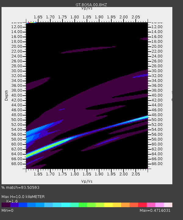
| Estimated Moho Depth: |
10.0 km |
| Estimated Crust Vp/Vs: |
1.60 |
| Assumed Crust Vp: |
6.459 km/s |
| Estimated Crust Vs: |
4.037 km/s |
| Estimated Crust Poisson's Ratio: |
0.18 |
|
| Radial Match: |
93.50593 % |
| Radial Bump: |
400 |
| Transverse Match: |
68.89677 % |
| Transverse Bump: |
400 |
| SOD ConfigId: |
25131211 |
| Insert Time: |
2021-08-26 18:52:04.970 +0000 |
| GWidth: |
2.5 |
| Max Bumps: |
400 |
| Tol: |
0.001 |
|
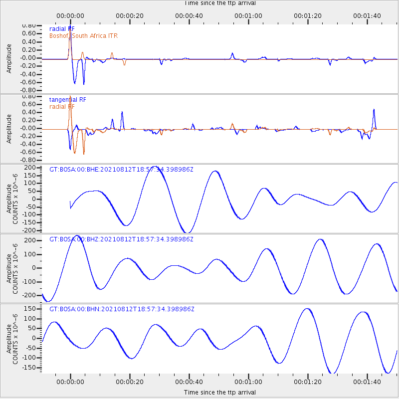
Signal To Noise
| Channel | StoN | STA | LTA |
| GT:BOSA:00:BHZ:20210812T18:57:34.398986Z | 1.5579594 | 2.4008914E-4 | 1.5410487E-4 |
| GT:BOSA:00:BHN:20210812T18:57:34.398986Z | 0.3551378 | 2.9852878E-5 | 8.405998E-5 |
| GT:BOSA:00:BHE:20210812T18:57:34.398986Z | 2.0248437 | 1.5652666E-4 | 7.730308E-5 |
| Arrivals |
| Ps | 1.0 SECOND |
| PpPs | 3.7 SECOND |
| PsPs/PpSs | 4.7 SECOND |


