You are here: Home > Network List > WI - West Indies IPGP Network Stations List
> Station MAGL Barre de l'ile, Marie-Galante, Guadeloupe > Earthquake Result Viewer
MAGL Barre de l'ile, Marie-Galante, Guadeloupe - Earthquake Result Viewer
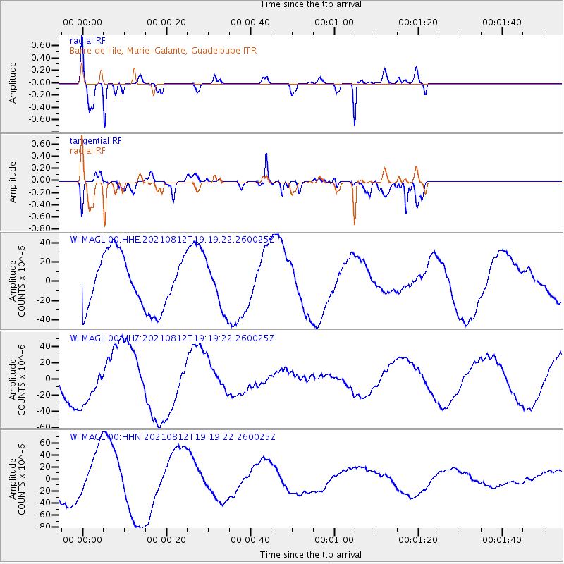
| Earthquake location: |
South Sandwich Islands Region |
| Earthquake latitude/longitude: |
-57.0/-25.3 |
| Earthquake time(UTC): |
2021/08/12 (224) 19:07:52 GMT |
| Earthquake Depth: |
19 km |
| Earthquake Magnitude: |
5.9 mb |
| Earthquake Catalog/Contributor: |
NEIC PDE/us |
|
| Network: |
WI West Indies IPGP Network |
| Station: |
MAGL Barre de l'ile, Marie-Galante, Guadeloupe |
| Lat/Lon: |
15.95 N/61.28 W |
| Elevation: |
159 m |
|
| Distance: |
78.6 deg |
| Az: |
324.749 deg |
| Baz: |
160.844 deg |
| Ray Param: |
0.049487516 |
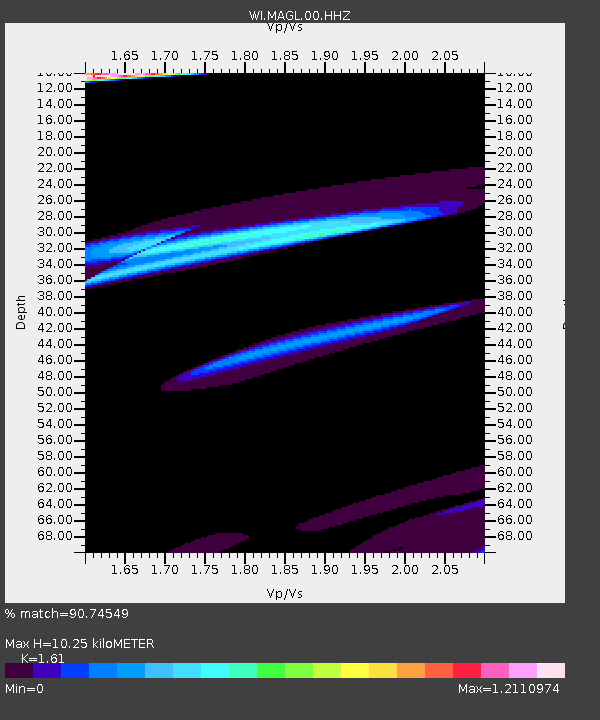
| Estimated Moho Depth: |
10.25 km |
| Estimated Crust Vp/Vs: |
1.61 |
| Assumed Crust Vp: |
5.88 km/s |
| Estimated Crust Vs: |
3.652 km/s |
| Estimated Crust Poisson's Ratio: |
0.19 |
|
| Radial Match: |
90.74549 % |
| Radial Bump: |
390 |
| Transverse Match: |
80.53619 % |
| Transverse Bump: |
400 |
| SOD ConfigId: |
25131211 |
| Insert Time: |
2021-08-26 19:12:12.924 +0000 |
| GWidth: |
2.5 |
| Max Bumps: |
400 |
| Tol: |
0.001 |
|
Signal To Noise
| Channel | StoN | STA | LTA |
| WI:MAGL:00:HHZ:20210812T19:19:22.260025Z | 1.7707361 | 2.6138163E-5 | 1.4761185E-5 |
| WI:MAGL:00:HHN:20210812T19:19:22.260025Z | 1.6773294 | 3.9275503E-5 | 2.3415496E-5 |
| WI:MAGL:00:HHE:20210812T19:19:22.260025Z | 0.8783799 | 2.3896911E-5 | 2.7205668E-5 |
| Arrivals |
| Ps | 1.1 SECOND |
| PpPs | 4.4 SECOND |
| PsPs/PpSs | 5.5 SECOND |


