You are here: Home > Network List > NM - Cooperative New Madrid Seismic Network Stations List
> Station SLM St. Louis, MO > Earthquake Result Viewer
SLM St. Louis, MO - Earthquake Result Viewer
| Earthquake location: |
Chile-Bolivia Border Region |
| Earthquake latitude/longitude: |
-22.3/-67.9 |
| Earthquake time(UTC): |
2005/11/17 (321) 19:26:56 GMT |
| Earthquake Depth: |
163 km |
| Earthquake Magnitude: |
6.0 MB, 6.9 MW, 6.8 MW |
| Earthquake Catalog/Contributor: |
WHDF/NEIC |
|
| Network: |
NM Cooperative New Madrid Seismic Network |
| Station: |
SLM St. Louis, MO |
| Lat/Lon: |
38.64 N/90.24 W |
| Elevation: |
186 m |
|
| Distance: |
64.2 deg |
| Az: |
340.677 deg |
| Baz: |
156.968 deg |
| Ray Param: |
0.058636457 |
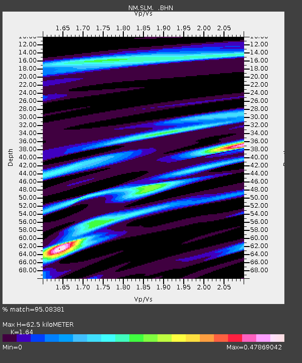
| Estimated Moho Depth: |
62.5 km |
| Estimated Crust Vp/Vs: |
1.64 |
| Assumed Crust Vp: |
6.498 km/s |
| Estimated Crust Vs: |
3.962 km/s |
| Estimated Crust Poisson's Ratio: |
0.20 |
|
| Radial Match: |
95.08381 % |
| Radial Bump: |
259 |
| Transverse Match: |
80.23152 % |
| Transverse Bump: |
400 |
| SOD ConfigId: |
2422 |
| Insert Time: |
2010-03-09 11:30:45.804 +0000 |
| GWidth: |
2.5 |
| Max Bumps: |
400 |
| Tol: |
0.001 |
|

Signal To Noise
| Channel | StoN | STA | LTA |
| NM:SLM: :BHN:20051117T19:36:42.72303Z | 8.506939 | 3.7156387E-6 | 4.367774E-7 |
| NM:SLM: :BHE:20051117T19:36:42.72303Z | 7.2232466 | 1.9086954E-6 | 2.6424343E-7 |
| NM:SLM: :BHZ:20051117T19:36:42.72303Z | 19.103664 | 9.551414E-6 | 4.999781E-7 |
| Arrivals |
| Ps | 6.5 SECOND |
| PpPs | 24 SECOND |
| PsPs/PpSs | 31 SECOND |


