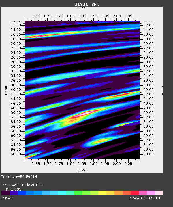
SLM St. Louis, MO - Earthquake Result Viewer

Earthquake location: Near West Coast Of Honshu, Japan
Earthquake latitude/longitude: 37.5/138.4
Earthquake time(UTC): 2007/07/16 (197) 01:13:22 GMT
Earthquake Depth: 12 km
Earthquake Magnitude: 6.5 MB, 6.4 MS, 6.6 MW, 6.5 MW
Earthquake Catalog/Contributor: WHDF/NEIC
Network: NM Cooperative New Madrid Seismic Network
Station: SLM St. Louis, MO
Lat/Lon: 38.64 N/90.24 W
Elevation: 186 m
Distance: 91.9 deg
Az: 36.054 deg
Baz: 323.316 deg
Ray Param: 0.04153333
Estimated Moho Depth: 50.0 km
Estimated Crust Vp/Vs: 1.87
Assumed Crust Vp: 6.498 km/s
Estimated Crust Vs: 3.484 km/s
Estimated Crust Poisson's Ratio: 0.30
Radial Match: 94.66414 %
Radial Bump: 356
Transverse Match: 85.72025 %
Transverse Bump: 400
SOD ConfigId: 2564
Insert Time: 2010-03-09 11:31:17.325 +0000
GWidth: 2.5
Max Bumps: 400
Tol: 0.001

Signal To Noise

ChannelStoNSTALTA
NM:SLM: :BHN:20070716T01:25:59.036016Z5.170825.714102E-71.1050669E-7
NM:SLM: :BHE:20070716T01:25:59.036016Z2.9817693.8136304E-71.2789825E-7
NM:SLM: :BHZ:20070716T01:25:59.036016Z26.5365522.3427797E-68.8285006E-8
Arrivals
Ps6.8 SECOND
PpPs22 SECOND
PsPs/PpSs28 SECOND