You are here: Home > Network List > NM - Cooperative New Madrid Seismic Network Stations List
> Station SLM St. Louis, MO > Earthquake Result Viewer
SLM St. Louis, MO - Earthquake Result Viewer
| Earthquake location: |
East Of Kuril Islands |
| Earthquake latitude/longitude: |
46.2/154.5 |
| Earthquake time(UTC): |
2007/01/13 (013) 04:23:21 GMT |
| Earthquake Depth: |
10 km |
| Earthquake Magnitude: |
7.3 MB, 8.2 MS, 8.1 MW, 7.9 MW |
| Earthquake Catalog/Contributor: |
WHDF/NEIC |
|
| Network: |
NM Cooperative New Madrid Seismic Network |
| Station: |
SLM St. Louis, MO |
| Lat/Lon: |
38.64 N/90.24 W |
| Elevation: |
186 m |
|
| Distance: |
77.5 deg |
| Az: |
46.511 deg |
| Baz: |
319.989 deg |
| Ray Param: |
0.05025929 |
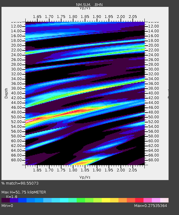
| Estimated Moho Depth: |
51.75 km |
| Estimated Crust Vp/Vs: |
1.60 |
| Assumed Crust Vp: |
6.498 km/s |
| Estimated Crust Vs: |
4.061 km/s |
| Estimated Crust Poisson's Ratio: |
0.18 |
|
| Radial Match: |
98.55073 % |
| Radial Bump: |
323 |
| Transverse Match: |
88.52866 % |
| Transverse Bump: |
400 |
| SOD ConfigId: |
2564 |
| Insert Time: |
2010-03-09 11:31:28.446 +0000 |
| GWidth: |
2.5 |
| Max Bumps: |
400 |
| Tol: |
0.001 |
|

Signal To Noise
| Channel | StoN | STA | LTA |
| NM:SLM: :BHN:20070113T04:34:45.686001Z | 6.331775 | 1.1110461E-6 | 1.7547151E-7 |
| NM:SLM: :BHE:20070113T04:34:45.686001Z | 3.2017183 | 7.541053E-7 | 2.3553143E-7 |
| NM:SLM: :BHZ:20070113T04:34:45.686001Z | 10.438248 | 3.4923012E-6 | 3.3456777E-7 |
| Arrivals |
| Ps | 4.9 SECOND |
| PpPs | 20 SECOND |
| PsPs/PpSs | 25 SECOND |


