You are here: Home > Network List > GS - US Geological Survey Networks Stations List
> Station DEC06 Boomer > Earthquake Result Viewer
DEC06 Boomer - Earthquake Result Viewer
*The percent match for this event was below the threshold and hence no stack was calculated.
| Earthquake location: |
South Of Alaska |
| Earthquake latitude/longitude: |
55.9/-157.0 |
| Earthquake time(UTC): |
2021/07/29 (210) 06:23:02 GMT |
| Earthquake Depth: |
35 km |
| Earthquake Magnitude: |
5.7 mb |
| Earthquake Catalog/Contributor: |
NEIC PDE/us |
|
| Network: |
GS US Geological Survey Networks |
| Station: |
DEC06 Boomer |
| Lat/Lon: |
39.90 N/88.95 W |
| Elevation: |
215 m |
|
| Distance: |
46.4 deg |
| Az: |
80.262 deg |
| Baz: |
313.78 deg |
| Ray Param: |
$rayparam |
*The percent match for this event was below the threshold and hence was not used in the summary stack. |
|
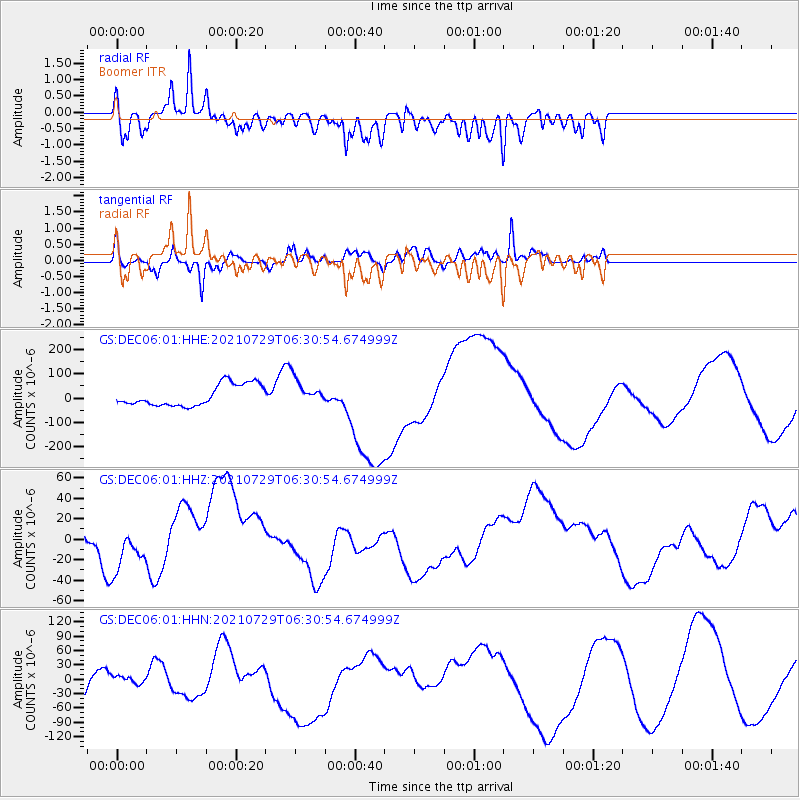
| Radial Match: |
51.180347 % |
| Radial Bump: |
400 |
| Transverse Match: |
60.806988 % |
| Transverse Bump: |
400 |
| SOD ConfigId: |
25131211 |
| Insert Time: |
2021-08-27 02:06:16.584 +0000 |
| GWidth: |
2.5 |
| Max Bumps: |
400 |
| Tol: |
0.001 |
|
Signal To Noise
| Channel | StoN | STA | LTA |
| GS:DEC06:01:HHZ:20210729T06:30:54.674999Z | 1.4482551 | 2.088509E-5 | 1.4420864E-5 |
| GS:DEC06:01:HHN:20210729T06:30:54.674999Z | 0.68940645 | 9.8032215E-6 | 1.42198E-5 |
| GS:DEC06:01:HHE:20210729T06:30:54.674999Z | 1.2858607 | 5.6114783E-5 | 4.3639862E-5 |
| Arrivals |
| Ps | |
| PpPs | |
| PsPs/PpSs | |


