You are here: Home > Network List > NM - Cooperative New Madrid Seismic Network Stations List
> Station SLM St. Louis, MO > Earthquake Result Viewer
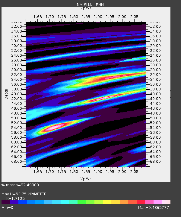
SLM St. Louis, MO - Earthquake Result Viewer
| Earthquake location: |
Near Coast Of Ecuador |
| Earthquake latitude/longitude: |
-0.6/-80.4 |
| Earthquake time(UTC): |
1998/08/04 (216) 18:59:20 GMT |
| Earthquake Depth: |
33 km |
| Earthquake Magnitude: |
6.2 MB, 7.1 MS, 7.1 UNKNOWN, 7.0 ME |
| Earthquake Catalog/Contributor: |
WHDF/NEIC |
|
| Network: |
NM Cooperative New Madrid Seismic Network |
| Station: |
SLM St. Louis, MO |
| Lat/Lon: |
38.64 N/90.24 W |
| Elevation: |
186 m |
|
| Distance: |
40.1 deg |
| Az: |
347.997 deg |
| Baz: |
164.601 deg |
| Ray Param: |
0.07453892 |
| Estimated Moho Depth: |
53.75 km |
| Estimated Crust Vp/Vs: |
1.71 |
| Assumed Crust Vp: |
6.498 km/s |
| Estimated Crust Vs: |
3.794 km/s |
| Estimated Crust Poisson's Ratio: |
0.24 |
|
| Radial Match: |
97.49989 % |
| Radial Bump: |
330 |
| Transverse Match: |
79.49467 % |
| Transverse Bump: |
400 |
| SOD ConfigId: |
4480 |
| Insert Time: |
2010-03-09 11:31:43.670 +0000 |
| GWidth: |
2.5 |
| Max Bumps: |
400 |
| Tol: |
0.001 |
|

Signal To Noise
| Channel | StoN | STA | LTA |
| NM:SLM: :BHN:19980804T19:06:21.878015Z | 7.1644793 | 1.5595044E-6 | 2.176717E-7 |
| NM:SLM: :BHE:19980804T19:06:21.877008Z | 4.986403 | 8.796174E-7 | 1.764032E-7 |
| NM:SLM: :BHZ:19980804T19:06:21.877008Z | 1.9206303 | 2.7625072E-7 | 1.4383336E-7 |
| Arrivals |
| Ps | 6.4 SECOND |
| PpPs | 21 SECOND |
| PsPs/PpSs | 27 SECOND |


