You are here: Home > Network List > NM - Cooperative New Madrid Seismic Network Stations List
> Station SLM St. Louis, MO > Earthquake Result Viewer
SLM St. Louis, MO - Earthquake Result Viewer
| Earthquake location: |
Samoa Islands Region |
| Earthquake latitude/longitude: |
-16.7/-172.7 |
| Earthquake time(UTC): |
2005/09/22 (265) 00:07:21 GMT |
| Earthquake Depth: |
10 km |
| Earthquake Magnitude: |
5.3 MB, 5.7 MS, 5.9 MW, 5.8 MW |
| Earthquake Catalog/Contributor: |
WHDF/NEIC |
|
| Network: |
NM Cooperative New Madrid Seismic Network |
| Station: |
SLM St. Louis, MO |
| Lat/Lon: |
38.64 N/90.24 W |
| Elevation: |
186 m |
|
| Distance: |
94.5 deg |
| Az: |
51.143 deg |
| Baz: |
252.369 deg |
| Ray Param: |
0.041031387 |
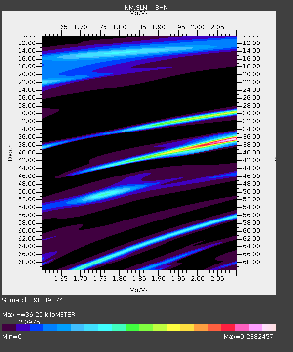
| Estimated Moho Depth: |
36.25 km |
| Estimated Crust Vp/Vs: |
2.10 |
| Assumed Crust Vp: |
6.498 km/s |
| Estimated Crust Vs: |
3.098 km/s |
| Estimated Crust Poisson's Ratio: |
0.35 |
|
| Radial Match: |
98.39174 % |
| Radial Bump: |
196 |
| Transverse Match: |
98.61704 % |
| Transverse Bump: |
189 |
| SOD ConfigId: |
2500 |
| Insert Time: |
2010-03-09 11:32:00.572 +0000 |
| GWidth: |
2.5 |
| Max Bumps: |
400 |
| Tol: |
0.001 |
|

Signal To Noise
| Channel | StoN | STA | LTA |
| NM:SLM: :BHN:20050922T00:20:10.022007Z | 1.1153667 | 2.5674474E-6 | 2.3018865E-6 |
| NM:SLM: :BHE:20050922T00:20:10.022007Z | 1.134889 | 1.5718073E-6 | 1.3849876E-6 |
| NM:SLM: :BHZ:20050922T00:20:10.022007Z | 1.1053848 | 2.1316148E-6 | 1.9283916E-6 |
| Arrivals |
| Ps | 6.2 SECOND |
| PpPs | 17 SECOND |
| PsPs/PpSs | 23 SECOND |


