You are here: Home > Network List > US - United States National Seismic Network Stations List
> Station MNTX Cornudas Mountains, Texas, USA > Earthquake Result Viewer
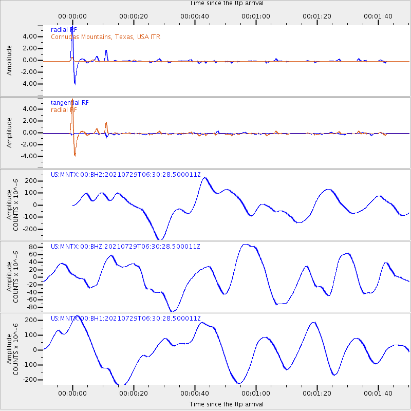
MNTX Cornudas Mountains, Texas, USA - Earthquake Result Viewer
*The percent match for this event was below the threshold and hence no stack was calculated.
| Earthquake location: |
South Of Alaska |
| Earthquake latitude/longitude: |
55.9/-157.0 |
| Earthquake time(UTC): |
2021/07/29 (210) 06:23:02 GMT |
| Earthquake Depth: |
35 km |
| Earthquake Magnitude: |
5.7 mb |
| Earthquake Catalog/Contributor: |
NEIC PDE/us |
|
| Network: |
US United States National Seismic Network |
| Station: |
MNTX Cornudas Mountains, Texas, USA |
| Lat/Lon: |
31.70 N/105.38 W |
| Elevation: |
404 m |
|
| Distance: |
43.1 deg |
| Az: |
102.047 deg |
| Baz: |
319.714 deg |
| Ray Param: |
$rayparam |
*The percent match for this event was below the threshold and hence was not used in the summary stack. |
|
| Radial Match: |
37.40752 % |
| Radial Bump: |
400 |
| Transverse Match: |
19.435923 % |
| Transverse Bump: |
232 |
| SOD ConfigId: |
25131211 |
| Insert Time: |
2021-08-27 02:18:02.214 +0000 |
| GWidth: |
2.5 |
| Max Bumps: |
400 |
| Tol: |
0.001 |
|
Signal To Noise
| Channel | StoN | STA | LTA |
| US:MNTX:00:BHZ:20210729T06:30:28.500011Z | 1.2970442 | 1.7683526E-5 | 1.363371E-5 |
| US:MNTX:00:BH1:20210729T06:30:28.500011Z | 4.39239 | 2.1792117E-4 | 4.9613347E-5 |
| US:MNTX:00:BH2:20210729T06:30:28.500011Z | 3.9744887 | 2.0304814E-4 | 5.1087864E-5 |
| Arrivals |
| Ps | |
| PpPs | |
| PsPs/PpSs | |


