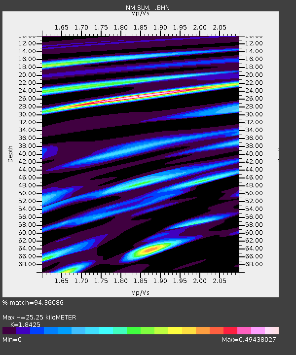
SLM St. Louis, MO - Earthquake Result Viewer

Earthquake location: Andreanof Islands, Aleutian Is.
Earthquake latitude/longitude: 51.2/-179.8
Earthquake time(UTC): 2001/06/14 (165) 19:48:47 GMT
Earthquake Depth: 18 km
Earthquake Magnitude: 6.0 MB, 6.3 MS, 6.5 MW, 6.1 ML
Earthquake Catalog/Contributor: WHDF/NEIC
Network: NM Cooperative New Madrid Seismic Network
Station: SLM St. Louis, MO
Lat/Lon: 38.64 N/90.24 W
Elevation: 186 m
Distance: 60.9 deg
Az: 63.69 deg
Baz: 313.883 deg
Ray Param: 0.061218616
Estimated Moho Depth: 25.25 km
Estimated Crust Vp/Vs: 1.84
Assumed Crust Vp: 6.498 km/s
Estimated Crust Vs: 3.526 km/s
Estimated Crust Poisson's Ratio: 0.29
Radial Match: 94.36086 %
Radial Bump: 395
Transverse Match: 88.23234 %
Transverse Bump: 400
SOD ConfigId: 4714
Insert Time: 2010-03-09 11:33:18.117 +0000
GWidth: 2.5
Max Bumps: 400
Tol: 0.001

Signal To Noise

ChannelStoNSTALTA
NM:SLM: :BHN:20010614T19:58:28.258997Z3.88499455.104542E-71.3139123E-7
NM:SLM: :BHE:20010614T19:58:28.258997Z4.1630485.2188363E-71.2536096E-7
NM:SLM: :BHZ:20010614T19:58:28.258997Z12.4849891.6320447E-61.3072055E-7
Arrivals
Ps3.4 SECOND
PpPs11 SECOND
PsPs/PpSs14 SECOND