You are here: Home > Network List > NM - Cooperative New Madrid Seismic Network Stations List
> Station SLM St. Louis, MO > Earthquake Result Viewer
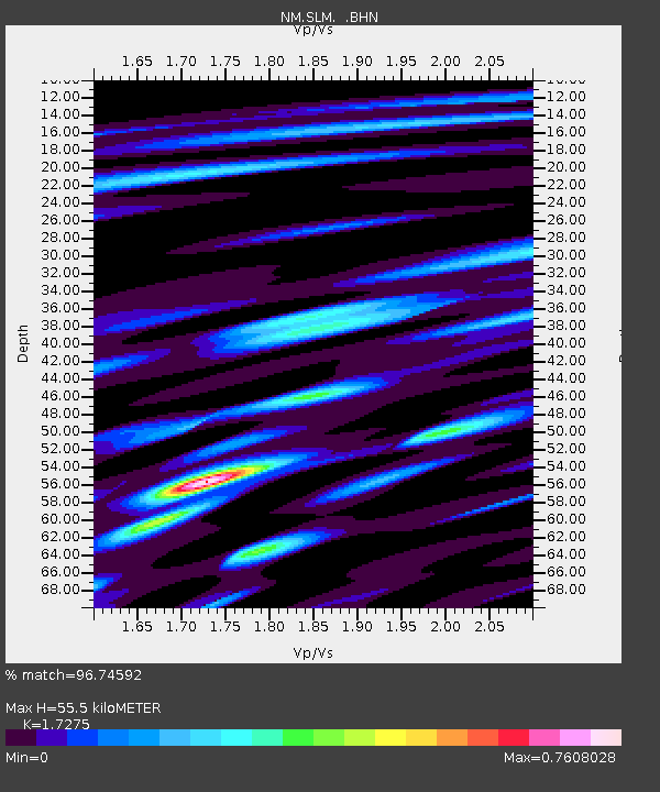
SLM St. Louis, MO - Earthquake Result Viewer
| Earthquake location: |
Near Coast Of Central Chile |
| Earthquake latitude/longitude: |
-29.7/-71.4 |
| Earthquake time(UTC): |
2002/04/01 (091) 19:59:32 GMT |
| Earthquake Depth: |
71 km |
| Earthquake Magnitude: |
6.1 MB, 6.4 MW, 6.4 MW |
| Earthquake Catalog/Contributor: |
WHDF/NEIC |
|
| Network: |
NM Cooperative New Madrid Seismic Network |
| Station: |
SLM St. Louis, MO |
| Lat/Lon: |
38.64 N/90.24 W |
| Elevation: |
186 m |
|
| Distance: |
70.2 deg |
| Az: |
344.397 deg |
| Baz: |
162.608 deg |
| Ray Param: |
0.05498065 |
| Estimated Moho Depth: |
55.5 km |
| Estimated Crust Vp/Vs: |
1.73 |
| Assumed Crust Vp: |
6.498 km/s |
| Estimated Crust Vs: |
3.761 km/s |
| Estimated Crust Poisson's Ratio: |
0.25 |
|
| Radial Match: |
96.74592 % |
| Radial Bump: |
305 |
| Transverse Match: |
92.24717 % |
| Transverse Bump: |
400 |
| SOD ConfigId: |
20082 |
| Insert Time: |
2010-03-09 11:33:44.453 +0000 |
| GWidth: |
2.5 |
| Max Bumps: |
400 |
| Tol: |
0.001 |
|

Signal To Noise
| Channel | StoN | STA | LTA |
| NM:SLM: :BHN:20020401T20:10:06.91103Z | 5.512128 | 9.178895E-7 | 1.6652182E-7 |
| NM:SLM: :BHE:20020401T20:10:06.91103Z | 2.7509756 | 4.03105E-7 | 1.4653165E-7 |
| NM:SLM: :BHZ:20020401T20:10:06.91103Z | 9.918549 | 2.1529206E-6 | 2.1706003E-7 |
| Arrivals |
| Ps | 6.5 SECOND |
| PpPs | 22 SECOND |
| PsPs/PpSs | 29 SECOND |


