You are here: Home > Network List > AK - Alaska Regional Network Stations List
> Station CUT Chulitna, AK, USA > Earthquake Result Viewer
CUT Chulitna, AK, USA - Earthquake Result Viewer
| Earthquake location: |
Mindoro, Philippines |
| Earthquake latitude/longitude: |
13.7/120.8 |
| Earthquake time(UTC): |
2021/08/13 (225) 15:08:32 GMT |
| Earthquake Depth: |
129 km |
| Earthquake Magnitude: |
5.8 mww |
| Earthquake Catalog/Contributor: |
NEIC PDE/us |
|
| Network: |
AK Alaska Regional Network |
| Station: |
CUT Chulitna, AK, USA |
| Lat/Lon: |
62.41 N/150.26 W |
| Elevation: |
574 m |
|
| Distance: |
77.5 deg |
| Az: |
28.486 deg |
| Baz: |
275.485 deg |
| Ray Param: |
0.050003767 |
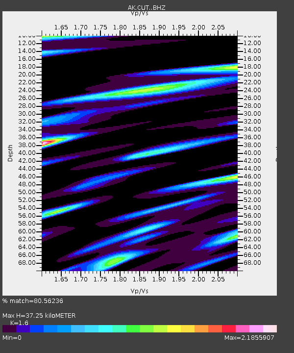
| Estimated Moho Depth: |
37.25 km |
| Estimated Crust Vp/Vs: |
1.60 |
| Assumed Crust Vp: |
6.438 km/s |
| Estimated Crust Vs: |
4.024 km/s |
| Estimated Crust Poisson's Ratio: |
0.18 |
|
| Radial Match: |
80.56236 % |
| Radial Bump: |
400 |
| Transverse Match: |
71.58665 % |
| Transverse Bump: |
400 |
| SOD ConfigId: |
25131211 |
| Insert Time: |
2021-08-27 15:10:12.534 +0000 |
| GWidth: |
2.5 |
| Max Bumps: |
400 |
| Tol: |
0.001 |
|
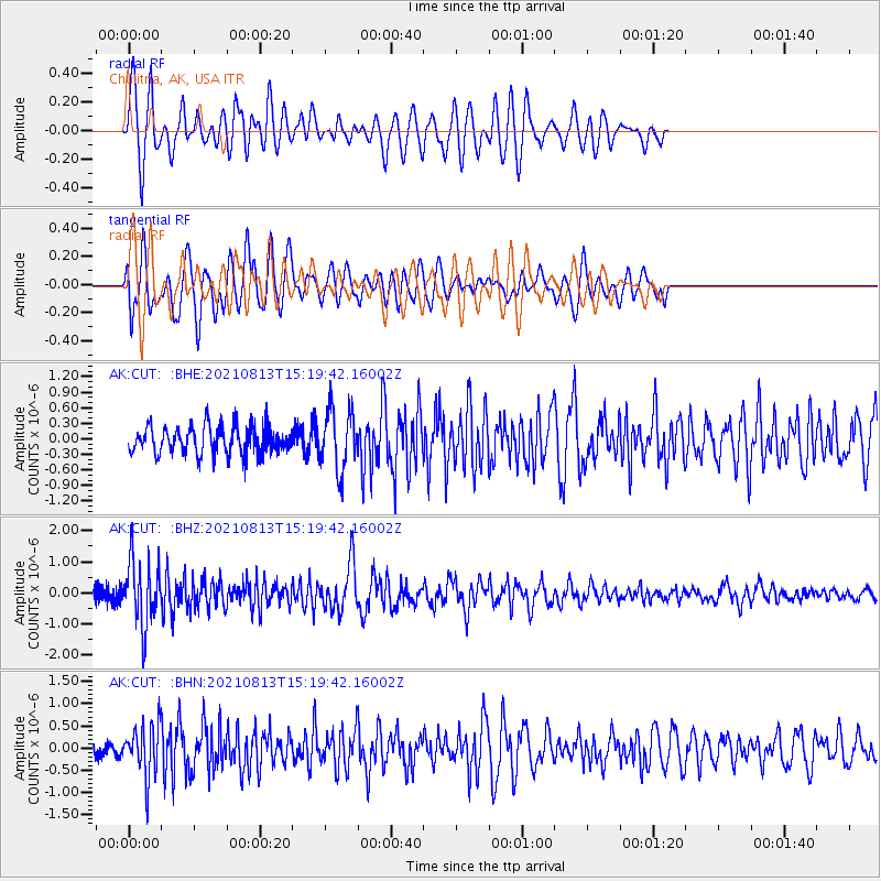
Signal To Noise
| Channel | StoN | STA | LTA |
| AK:CUT: :BHZ:20210813T15:19:42.16002Z | 3.435153 | 1.0388077E-6 | 3.0240506E-7 |
| AK:CUT: :BHN:20210813T15:19:42.16002Z | 2.1012452 | 5.741627E-7 | 2.7324882E-7 |
| AK:CUT: :BHE:20210813T15:19:42.16002Z | 2.1610224 | 5.801006E-7 | 2.6843804E-7 |
| Arrivals |
| Ps | 3.6 SECOND |
| PpPs | 15 SECOND |
| PsPs/PpSs | 18 SECOND |


