You are here: Home > Network List > AK - Alaska Regional Network Stations List
> Station H20K Anotleneega Mountain, AK, USA > Earthquake Result Viewer
H20K Anotleneega Mountain, AK, USA - Earthquake Result Viewer
| Earthquake location: |
Mindoro, Philippines |
| Earthquake latitude/longitude: |
13.7/120.8 |
| Earthquake time(UTC): |
2021/08/13 (225) 15:08:32 GMT |
| Earthquake Depth: |
129 km |
| Earthquake Magnitude: |
5.8 mww |
| Earthquake Catalog/Contributor: |
NEIC PDE/us |
|
| Network: |
AK Alaska Regional Network |
| Station: |
H20K Anotleneega Mountain, AK, USA |
| Lat/Lon: |
65.49 N/154.88 W |
| Elevation: |
514 m |
|
| Distance: |
75.3 deg |
| Az: |
25.415 deg |
| Baz: |
270.616 deg |
| Ray Param: |
0.05147381 |
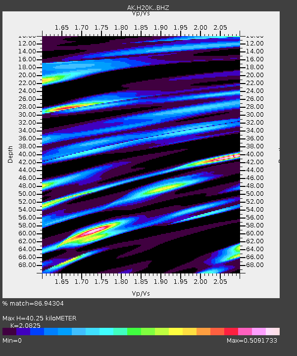
| Estimated Moho Depth: |
40.25 km |
| Estimated Crust Vp/Vs: |
2.08 |
| Assumed Crust Vp: |
6.566 km/s |
| Estimated Crust Vs: |
3.153 km/s |
| Estimated Crust Poisson's Ratio: |
0.35 |
|
| Radial Match: |
86.94304 % |
| Radial Bump: |
400 |
| Transverse Match: |
77.58986 % |
| Transverse Bump: |
400 |
| SOD ConfigId: |
25131211 |
| Insert Time: |
2021-08-27 15:11:06.119 +0000 |
| GWidth: |
2.5 |
| Max Bumps: |
400 |
| Tol: |
0.001 |
|

Signal To Noise
| Channel | StoN | STA | LTA |
| AK:H20K: :BHZ:20210813T15:19:29.780015Z | 13.1911 | 8.1218303E-7 | 6.157053E-8 |
| AK:H20K: :BHN:20210813T15:19:29.780015Z | 1.5457921 | 8.331131E-8 | 5.389555E-8 |
| AK:H20K: :BHE:20210813T15:19:29.780015Z | 6.1539125 | 2.954878E-7 | 4.801625E-8 |
| Arrivals |
| Ps | 6.8 SECOND |
| PpPs | 18 SECOND |
| PsPs/PpSs | 25 SECOND |


