You are here: Home > Network List > AK - Alaska Regional Network Stations List
> Station L22K Petersville, AK, USA > Earthquake Result Viewer
L22K Petersville, AK, USA - Earthquake Result Viewer
| Earthquake location: |
Mindoro, Philippines |
| Earthquake latitude/longitude: |
13.7/120.8 |
| Earthquake time(UTC): |
2021/08/13 (225) 15:08:32 GMT |
| Earthquake Depth: |
129 km |
| Earthquake Magnitude: |
5.8 mww |
| Earthquake Catalog/Contributor: |
NEIC PDE/us |
|
| Network: |
AK Alaska Regional Network |
| Station: |
L22K Petersville, AK, USA |
| Lat/Lon: |
62.53 N/150.77 W |
| Elevation: |
817 m |
|
| Distance: |
77.2 deg |
| Az: |
28.385 deg |
| Baz: |
275.014 deg |
| Ray Param: |
0.050169557 |
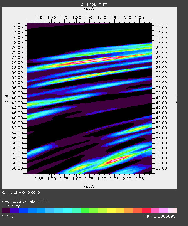
| Estimated Moho Depth: |
24.75 km |
| Estimated Crust Vp/Vs: |
1.88 |
| Assumed Crust Vp: |
6.438 km/s |
| Estimated Crust Vs: |
3.425 km/s |
| Estimated Crust Poisson's Ratio: |
0.30 |
|
| Radial Match: |
86.83043 % |
| Radial Bump: |
400 |
| Transverse Match: |
82.35973 % |
| Transverse Bump: |
400 |
| SOD ConfigId: |
25131211 |
| Insert Time: |
2021-08-27 15:11:52.289 +0000 |
| GWidth: |
2.5 |
| Max Bumps: |
400 |
| Tol: |
0.001 |
|

Signal To Noise
| Channel | StoN | STA | LTA |
| AK:L22K: :BHZ:20210813T15:19:40.799973Z | 8.375268 | 8.580342E-7 | 1.0244857E-7 |
| AK:L22K: :BHN:20210813T15:19:40.799973Z | 4.422949 | 3.6110401E-7 | 8.164327E-8 |
| AK:L22K: :BHE:20210813T15:19:40.799973Z | 6.8025966 | 4.231452E-7 | 6.220348E-8 |
| Arrivals |
| Ps | 3.5 SECOND |
| PpPs | 11 SECOND |
| PsPs/PpSs | 14 SECOND |


