You are here: Home > Network List > CN - Canadian National Seismograph Network Stations List
> Station INK INUVIK, NT > Earthquake Result Viewer
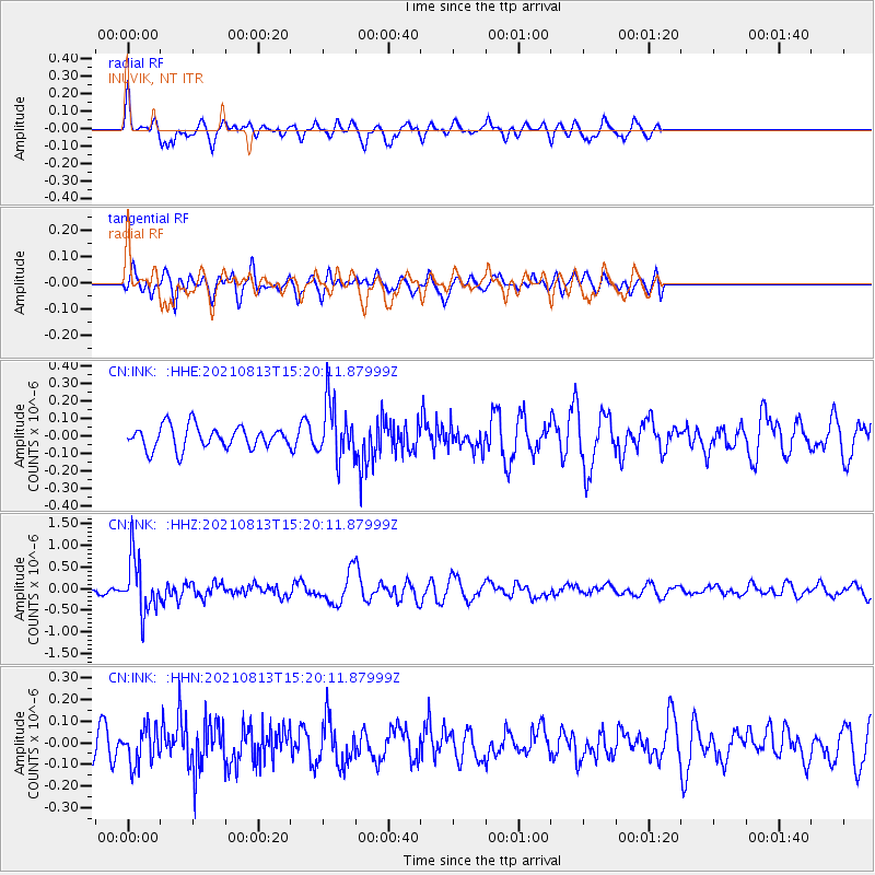
INK INUVIK, NT - Earthquake Result Viewer
*The percent match for this event was below the threshold and hence no stack was calculated.
| Earthquake location: |
Mindoro, Philippines |
| Earthquake latitude/longitude: |
13.7/120.8 |
| Earthquake time(UTC): |
2021/08/13 (225) 15:08:32 GMT |
| Earthquake Depth: |
129 km |
| Earthquake Magnitude: |
5.8 mww |
| Earthquake Catalog/Contributor: |
NEIC PDE/us |
|
| Network: |
CN Canadian National Seismograph Network |
| Station: |
INK INUVIK, NT |
| Lat/Lon: |
68.31 N/133.53 W |
| Elevation: |
44 m |
|
| Distance: |
83.0 deg |
| Az: |
21.141 deg |
| Baz: |
289.473 deg |
| Ray Param: |
$rayparam |
*The percent match for this event was below the threshold and hence was not used in the summary stack. |
|
| Radial Match: |
68.24722 % |
| Radial Bump: |
400 |
| Transverse Match: |
51.495617 % |
| Transverse Bump: |
400 |
| SOD ConfigId: |
25131211 |
| Insert Time: |
2021-08-27 15:17:38.583 +0000 |
| GWidth: |
2.5 |
| Max Bumps: |
400 |
| Tol: |
0.001 |
|
Signal To Noise
| Channel | StoN | STA | LTA |
| CN:INK: :HHZ:20210813T15:20:11.87999Z | 6.255356 | 6.2875284E-7 | 1.0051433E-7 |
| CN:INK: :HHN:20210813T15:20:11.87999Z | 1.2972156 | 8.457255E-8 | 6.5195444E-8 |
| CN:INK: :HHE:20210813T15:20:11.87999Z | 2.488352 | 1.5883717E-7 | 6.383227E-8 |
| Arrivals |
| Ps | |
| PpPs | |
| PsPs/PpSs | |


