You are here: Home > Network List > BL - Brazilian Lithospheric Seismic Project (BLSP) Stations List
> Station PMNB Patos de Minas, MG > Earthquake Result Viewer
PMNB Patos de Minas, MG - Earthquake Result Viewer
| Earthquake location: |
South Sandwich Islands Region |
| Earthquake latitude/longitude: |
-60.0/-26.4 |
| Earthquake time(UTC): |
2021/08/12 (224) 18:36:59 GMT |
| Earthquake Depth: |
35 km |
| Earthquake Magnitude: |
6.7 mb |
| Earthquake Catalog/Contributor: |
NEIC PDE/us |
|
| Network: |
BL Brazilian Lithospheric Seismic Project (BLSP) |
| Station: |
PMNB Patos de Minas, MG |
| Lat/Lon: |
18.54 S/46.44 W |
| Elevation: |
950 m |
|
| Distance: |
43.8 deg |
| Az: |
332.044 deg |
| Baz: |
165.614 deg |
| Ray Param: |
0.07222526 |
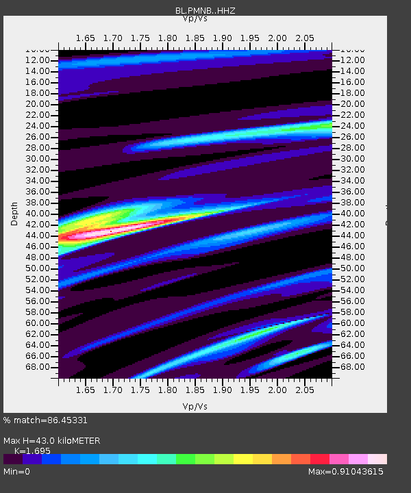
| Estimated Moho Depth: |
43.0 km |
| Estimated Crust Vp/Vs: |
1.70 |
| Assumed Crust Vp: |
6.419 km/s |
| Estimated Crust Vs: |
3.787 km/s |
| Estimated Crust Poisson's Ratio: |
0.23 |
|
| Radial Match: |
86.45331 % |
| Radial Bump: |
281 |
| Transverse Match: |
73.99837 % |
| Transverse Bump: |
400 |
| SOD ConfigId: |
25131211 |
| Insert Time: |
2021-08-27 22:53:12.029 +0000 |
| GWidth: |
2.5 |
| Max Bumps: |
400 |
| Tol: |
0.001 |
|

Signal To Noise
| Channel | StoN | STA | LTA |
| BL:PMNB: :HHZ:20210812T18:44:31.880015Z | 2.7625349 | 3.2952918E-5 | 1.1928507E-5 |
| BL:PMNB: :HHN:20210812T18:44:31.880015Z | 2.6961465 | 2.0237385E-5 | 7.506041E-6 |
| BL:PMNB: :HHE:20210812T18:44:31.880015Z | 1.7149063 | 6.565423E-6 | 3.8284443E-6 |
| Arrivals |
| Ps | 5.0 SECOND |
| PpPs | 17 SECOND |
| PsPs/PpSs | 22 SECOND |


