You are here: Home > Network List > G - GEOSCOPE Stations List
> Station FDFM Morne la Rosette, Martinique, France > Earthquake Result Viewer
FDFM Morne la Rosette, Martinique, France - Earthquake Result Viewer
| Earthquake location: |
South Sandwich Islands Region |
| Earthquake latitude/longitude: |
-60.0/-26.4 |
| Earthquake time(UTC): |
2021/08/12 (224) 18:36:59 GMT |
| Earthquake Depth: |
35 km |
| Earthquake Magnitude: |
6.7 mb |
| Earthquake Catalog/Contributor: |
NEIC PDE/us |
|
| Network: |
G GEOSCOPE |
| Station: |
FDFM Morne la Rosette, Martinique, France |
| Lat/Lon: |
14.73 N/61.16 W |
| Elevation: |
320 m |
|
| Distance: |
79.6 deg |
| Az: |
325.91 deg |
| Baz: |
163.066 deg |
| Ray Param: |
0.04883583 |
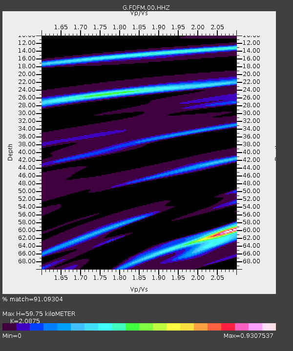
| Estimated Moho Depth: |
59.75 km |
| Estimated Crust Vp/Vs: |
2.09 |
| Assumed Crust Vp: |
5.88 km/s |
| Estimated Crust Vs: |
2.817 km/s |
| Estimated Crust Poisson's Ratio: |
0.35 |
|
| Radial Match: |
91.09304 % |
| Radial Bump: |
400 |
| Transverse Match: |
65.32839 % |
| Transverse Bump: |
400 |
| SOD ConfigId: |
25131211 |
| Insert Time: |
2021-08-27 22:54:23.196 +0000 |
| GWidth: |
2.5 |
| Max Bumps: |
400 |
| Tol: |
0.001 |
|

Signal To Noise
| Channel | StoN | STA | LTA |
| G:FDFM:00:HHZ:20210812T18:48:31.990Z | 1.1584076 | 1.4843692E-5 | 1.2813877E-5 |
| G:FDFM:00:HHN:20210812T18:48:31.990Z | 1.8573318 | 1.1764352E-5 | 6.334007E-6 |
| G:FDFM:00:HHE:20210812T18:48:31.990Z | 1.0548195 | 4.1261537E-6 | 3.9117153E-6 |
| Arrivals |
| Ps | 11 SECOND |
| PpPs | 31 SECOND |
| PsPs/PpSs | 42 SECOND |


