You are here: Home > Network List > G - GEOSCOPE Stations List
> Station MPG Montagne des Peres, French Guyana > Earthquake Result Viewer
MPG Montagne des Peres, French Guyana - Earthquake Result Viewer
| Earthquake location: |
South Sandwich Islands Region |
| Earthquake latitude/longitude: |
-60.0/-26.4 |
| Earthquake time(UTC): |
2021/08/12 (224) 18:36:59 GMT |
| Earthquake Depth: |
35 km |
| Earthquake Magnitude: |
6.7 mb |
| Earthquake Catalog/Contributor: |
NEIC PDE/us |
|
| Network: |
G GEOSCOPE |
| Station: |
MPG Montagne des Peres, French Guyana |
| Lat/Lon: |
5.11 N/52.64 W |
| Elevation: |
147 m |
|
| Distance: |
68.1 deg |
| Az: |
331.694 deg |
| Baz: |
166.151 deg |
| Ray Param: |
0.05646621 |
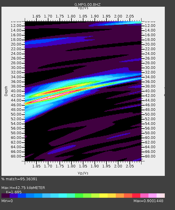
| Estimated Moho Depth: |
42.75 km |
| Estimated Crust Vp/Vs: |
1.70 |
| Assumed Crust Vp: |
6.472 km/s |
| Estimated Crust Vs: |
3.818 km/s |
| Estimated Crust Poisson's Ratio: |
0.23 |
|
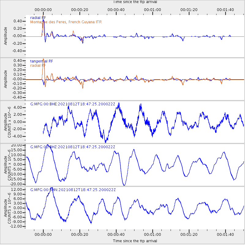
| Radial Match: |
95.36391 % |
| Radial Bump: |
360 |
| Transverse Match: |
69.271805 % |
| Transverse Bump: |
400 |
| SOD ConfigId: |
25131211 |
| Insert Time: |
2021-08-27 22:54:26.135 +0000 |
| GWidth: |
2.5 |
| Max Bumps: |
400 |
| Tol: |
0.001 |
|
Signal To Noise
| Channel | StoN | STA | LTA |
| G:MPG:00:BHZ:20210812T18:47:25.200022Z | 1.6632868 | 1.5223791E-5 | 9.152835E-6 |
| G:MPG:00:BHN:20210812T18:47:25.200022Z | 1.7409053 | 7.967479E-6 | 4.57663E-6 |
| G:MPG:00:BHE:20210812T18:47:25.200022Z | 1.8006845 | 3.2686773E-6 | 1.8152416E-6 |
| Arrivals |
| Ps | 4.8 SECOND |
| PpPs | 17 SECOND |
| PsPs/PpSs | 22 SECOND |


