You are here: Home > Network List > GT - Global Telemetered Seismograph Network (USAF/USGS) Stations List
> Station PLCA Paso Flores, Argentina > Earthquake Result Viewer
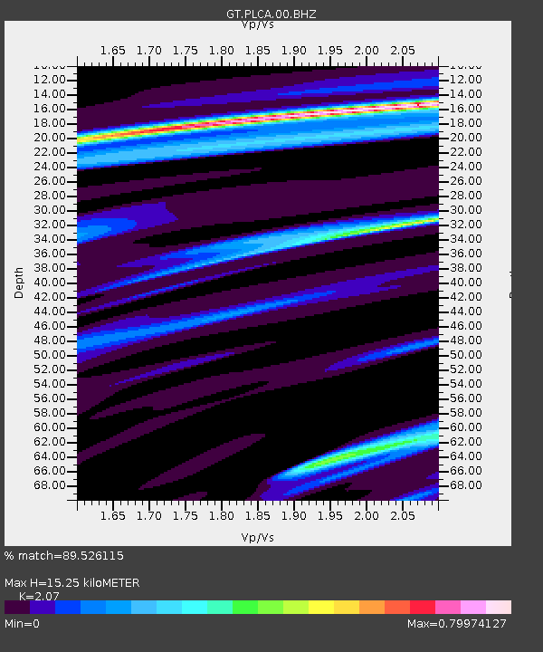
PLCA Paso Flores, Argentina - Earthquake Result Viewer
| Earthquake location: |
South Sandwich Islands Region |
| Earthquake latitude/longitude: |
-60.0/-26.4 |
| Earthquake time(UTC): |
2021/08/12 (224) 18:36:59 GMT |
| Earthquake Depth: |
35 km |
| Earthquake Magnitude: |
6.7 mb |
| Earthquake Catalog/Contributor: |
NEIC PDE/us |
|
| Network: |
GT Global Telemetered Seismograph Network (USAF/USGS) |
| Station: |
PLCA Paso Flores, Argentina |
| Lat/Lon: |
40.73 S/70.55 W |
| Elevation: |
1080 m |
|
| Distance: |
33.3 deg |
| Az: |
285.3 deg |
| Baz: |
140.342 deg |
| Ray Param: |
0.07824479 |
| Estimated Moho Depth: |
15.25 km |
| Estimated Crust Vp/Vs: |
2.07 |
| Assumed Crust Vp: |
6.597 km/s |
| Estimated Crust Vs: |
3.187 km/s |
| Estimated Crust Poisson's Ratio: |
0.35 |
|
| Radial Match: |
89.526115 % |
| Radial Bump: |
340 |
| Transverse Match: |
64.92388 % |
| Transverse Bump: |
400 |
| SOD ConfigId: |
25131211 |
| Insert Time: |
2021-08-27 22:54:42.894 +0000 |
| GWidth: |
2.5 |
| Max Bumps: |
400 |
| Tol: |
0.001 |
|

Signal To Noise
| Channel | StoN | STA | LTA |
| GT:PLCA:00:BHZ:20210812T18:43:03.449992Z | 1.15015 | 2.3616558E-5 | 2.053346E-5 |
| GT:PLCA:00:BHN:20210812T18:43:03.449992Z | 1.4169537 | 1.5064864E-5 | 1.0631868E-5 |
| GT:PLCA:00:BHE:20210812T18:43:03.449992Z | 1.7735287 | 2.1055286E-5 | 1.1871973E-5 |
| Arrivals |
| Ps | 2.7 SECOND |
| PpPs | 6.6 SECOND |
| PsPs/PpSs | 9.3 SECOND |


