You are here: Home > Network List > TC - Red Sismólogica Nacional de Costa Rica Stations List
> Station MARA Maravilla > Earthquake Result Viewer
MARA Maravilla - Earthquake Result Viewer
| Earthquake location: |
South Sandwich Islands Region |
| Earthquake latitude/longitude: |
-60.0/-26.4 |
| Earthquake time(UTC): |
2021/08/12 (224) 18:36:59 GMT |
| Earthquake Depth: |
35 km |
| Earthquake Magnitude: |
6.7 mb |
| Earthquake Catalog/Contributor: |
NEIC PDE/us |
|
| Network: |
TC Red Sismólogica Nacional de Costa Rica |
| Station: |
MARA Maravilla |
| Lat/Lon: |
10.02 N/85.43 W |
| Elevation: |
629 m |
|
| Distance: |
83.9 deg |
| Az: |
301.9 deg |
| Baz: |
154.317 deg |
| Ray Param: |
0.04578749 |
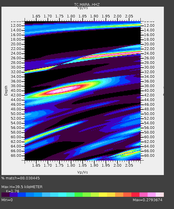
| Estimated Moho Depth: |
39.5 km |
| Estimated Crust Vp/Vs: |
1.76 |
| Assumed Crust Vp: |
6.597 km/s |
| Estimated Crust Vs: |
3.749 km/s |
| Estimated Crust Poisson's Ratio: |
0.26 |
|
| Radial Match: |
88.038445 % |
| Radial Bump: |
258 |
| Transverse Match: |
69.95805 % |
| Transverse Bump: |
400 |
| SOD ConfigId: |
25131211 |
| Insert Time: |
2021-08-27 22:56:29.311 +0000 |
| GWidth: |
2.5 |
| Max Bumps: |
400 |
| Tol: |
0.001 |
|

Signal To Noise
| Channel | StoN | STA | LTA |
| TC:MARA: :HHZ:20210812T18:48:54.979991Z | 3.07382 | 8.6819346E-5 | 2.824477E-5 |
| TC:MARA: :HHN:20210812T18:48:54.979991Z | 5.133225 | 3.6606463E-5 | 7.1312793E-6 |
| TC:MARA: :HHE:20210812T18:48:54.979991Z | 1.0841002 | 7.247693E-6 | 6.685445E-6 |
| Arrivals |
| Ps | 4.7 SECOND |
| PpPs | 16 SECOND |
| PsPs/PpSs | 21 SECOND |


