You are here: Home > Network List > S1 - Australian Seismometers in Schools Stations List
> Station AUBSH Beerwah State High School > Earthquake Result Viewer
AUBSH Beerwah State High School - Earthquake Result Viewer
| Earthquake location: |
South Sandwich Islands Region |
| Earthquake latitude/longitude: |
-60.4/-26.8 |
| Earthquake time(UTC): |
2021/08/12 (224) 18:41:22 GMT |
| Earthquake Depth: |
35 km |
| Earthquake Magnitude: |
6.1 mb |
| Earthquake Catalog/Contributor: |
NEIC PDE/us |
|
| Network: |
S1 Australian Seismometers in Schools |
| Station: |
AUBSH Beerwah State High School |
| Lat/Lon: |
26.86 S/152.95 E |
| Elevation: |
26 m |
|
| Distance: |
93.1 deg |
| Az: |
179.746 deg |
| Baz: |
180.141 deg |
| Ray Param: |
0.041324623 |
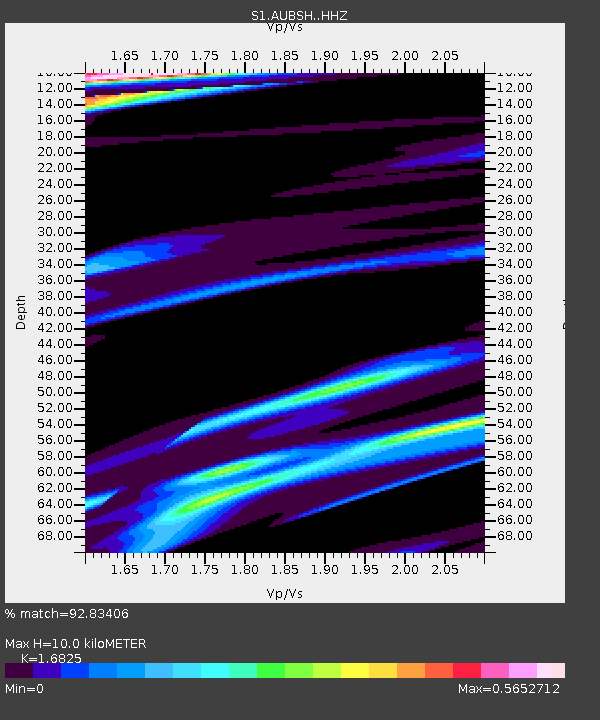
| Estimated Moho Depth: |
10.0 km |
| Estimated Crust Vp/Vs: |
1.68 |
| Assumed Crust Vp: |
6.472 km/s |
| Estimated Crust Vs: |
3.847 km/s |
| Estimated Crust Poisson's Ratio: |
0.23 |
|
| Radial Match: |
92.83406 % |
| Radial Bump: |
271 |
| Transverse Match: |
76.45852 % |
| Transverse Bump: |
400 |
| SOD ConfigId: |
25131211 |
| Insert Time: |
2021-08-27 23:29:35.268 +0000 |
| GWidth: |
2.5 |
| Max Bumps: |
400 |
| Tol: |
0.001 |
|

Signal To Noise
| Channel | StoN | STA | LTA |
| S1:AUBSH: :HHZ:20210812T18:54:01.479983Z | 0.50352275 | 4.180823E-6 | 8.3031455E-6 |
| S1:AUBSH: :HHN:20210812T18:54:01.479983Z | 1.0847774 | 5.8933583E-6 | 5.432781E-6 |
| S1:AUBSH: :HHE:20210812T18:54:01.479983Z | 2.7516258 | 3.3217302E-6 | 1.2071882E-6 |
| Arrivals |
| Ps | 1.1 SECOND |
| PpPs | 4.1 SECOND |
| PsPs/PpSs | 5.1 SECOND |


