You are here: Home > Network List > NM - Cooperative New Madrid Seismic Network Stations List
> Station UALR University of Arkansas, Little Rock > Earthquake Result Viewer
UALR University of Arkansas, Little Rock - Earthquake Result Viewer
| Earthquake location: |
East Of Kuril Islands |
| Earthquake latitude/longitude: |
46.9/155.2 |
| Earthquake time(UTC): |
2009/01/15 (015) 17:49:39 GMT |
| Earthquake Depth: |
36 km |
| Earthquake Magnitude: |
6.9 MB, 7.5 MS, 7.4 MW, 7.4 MW |
| Earthquake Catalog/Contributor: |
WHDF/NEIC |
|
| Network: |
NM Cooperative New Madrid Seismic Network |
| Station: |
UALR University of Arkansas, Little Rock |
| Lat/Lon: |
34.78 N/92.34 W |
| Elevation: |
138 m |
|
| Distance: |
78.7 deg |
| Az: |
50.866 deg |
| Baz: |
319.71 deg |
| Ray Param: |
0.04944372 |
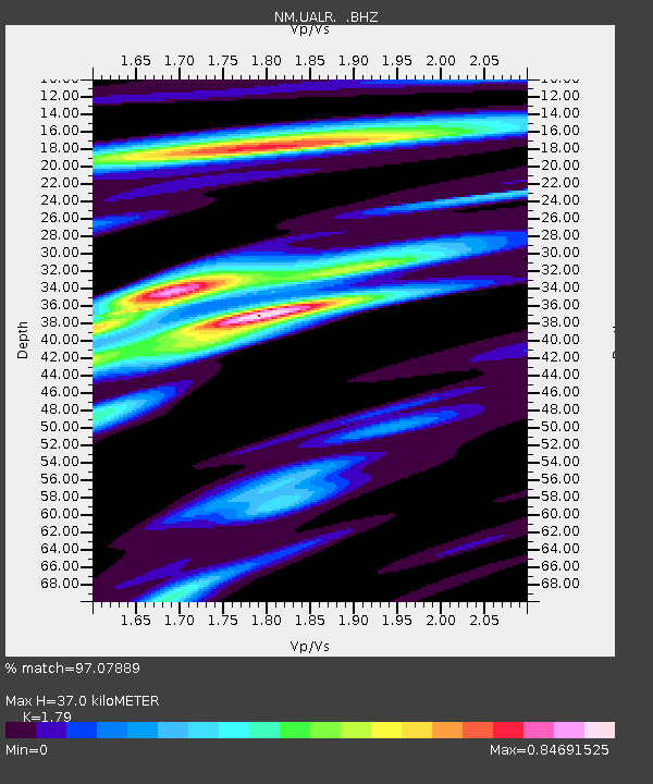
| Estimated Moho Depth: |
37.0 km |
| Estimated Crust Vp/Vs: |
1.79 |
| Assumed Crust Vp: |
6.498 km/s |
| Estimated Crust Vs: |
3.63 km/s |
| Estimated Crust Poisson's Ratio: |
0.27 |
|
| Radial Match: |
97.07889 % |
| Radial Bump: |
353 |
| Transverse Match: |
92.42018 % |
| Transverse Bump: |
400 |
| SOD ConfigId: |
2834 |
| Insert Time: |
2010-03-09 11:35:58.896 +0000 |
| GWidth: |
2.5 |
| Max Bumps: |
400 |
| Tol: |
0.001 |
|

Signal To Noise
| Channel | StoN | STA | LTA |
| NM:UALR: :BHZ:20090115T18:01:06.293999Z | 15.668283 | 9.215164E-6 | 5.8814123E-7 |
| NM:UALR: :BHN:20090115T18:01:06.293999Z | 3.9491963 | 2.0048362E-6 | 5.0765675E-7 |
| NM:UALR: :BHE:20090115T18:01:06.293999Z | 3.2508297 | 1.9554552E-6 | 6.0152496E-7 |
| Arrivals |
| Ps | 4.6 SECOND |
| PpPs | 15 SECOND |
| PsPs/PpSs | 20 SECOND |


